SketchUp SKP
GIS File Name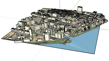
CAMB3D_[Tile Name (ex: E_2)]_SKP_Buildings_skp.zip
Updated
August 2021
Format
SketchUp
Description
The City of Cambridge Geographic Information System (GIS) City-Wide 3D project provides a detailed three-dimensional model of buildings and bridges has been compiled from many sources over several years. The SketchUp building model collection provides 3D models for modeling, model transformation, and web visualization. The model collection is segmented into tiles which is contiguous with the City of Boston 3D tile grid. Each model being assigned to the tile that its centroid falls within.
The Tiled 3D Model is a combination of terrain with a draped basemap with a collection of 3D building models. These layers have been transformed from the city's GIS data into a SketchUp model that is easy to explore and to edit. SketchUp is available free for non-commercial use.
Purpose
The City of Cambridge GIS maintains a 3D model of the city as a visualization and analytical tool for understanding ideas related to the future of the City. The Cambridge 3D model is constructed of several components: Terrain, Ground plan, and 3D models of buildings and bridges. Each of these components is shared in formats intended to facilitate collaboration between diverse communities who have an interest in understanding places in the city as they have changed or as they may be changed.
Download Tiled Data
View 3D Data Download Map
Sources
Each SketchUp model is a combination of three datasets, which are in turn created from multiple sources.
Coordinate System
Projected Coordinate System: State Plane Massachusetts Mainland (Feet), North American Datum of 1983.
Vertical Coordinate System for 3D data: North American Vertical Datum, 1988 (NAVD 88) Feet (Height)
Usage Notes
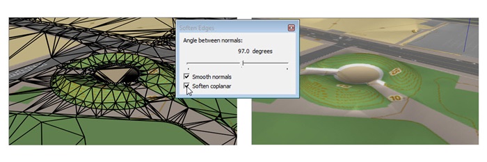
- The terrain looks better if you use the Window > Soften / Smooth Edges to soften coplanar edges within 50 Degrees.
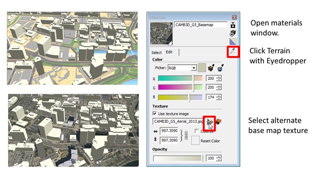
- To skin the terrain with the 2013 or 1946 Aerial photo or a custom basemap image use the Materials > Eye Dropper to select the terrain material, then choose the desired ground plan image in the Edit tab.
-
Warning when working with SketchUp files in Rhino
Within each SketchUp tile, the ground plan texture is named Terrain_.png. Sketchup does not have a problem with this; but Rhino seems to be ignoring new texture images if it thinks that they already exist in the model. This will be fixed in our next release. In the short term, the workaround would be to download the ground plan image for each tile from the download map (Ground plan Maps tab). Then in Rhino, you should be able to find the Material properties of each terrain mesh and redirect the image reference to the appropriate image for that tile.