- GIS >
- 3D >
- Digital Submission
Digital Submission
The City of Cambridge Community Development Department (CDD) and Geographic Information System (GIS) group have collaborated to develop a citywide virtual three-dimensional (3D) model, which includes digital representations of buildings, terrain, and site plans for the city. The main purpose of our citywide model is to provide designers with a rich context model for their design studies and to provide residents with updates of existing and future development in the City.
The latest version of the model may be downloaded from the Cambridge GIS 3D downloads page (cambridgema.gov/GIS/3D/3ddata). In the model, the city has been divided into a grid system allowing users to download 3D data for a specific area in a variety of formats. The entire city model is also available in ESRI multi-patch format.
Model Submission Guidelines
To pilot the process of incorporating permitted new development into the citywide model, CDD is requesting digital 3D building models for new construction projects after they have received special permits from the Planning Board or have completed Large Project Review advisory procedures.
The purpose is to enhance the citywide 3D model by including new buildings that have been permitted or are under construction, which allows the model to stay current with the evolving urban fabric of the city.
These Draft Model Submission Guidelines are intended to make it as easy as possible to format a project model that may be brought into the citywide model or into a specific planning district model. We welcome feedback on ways that the model or the submission guidelines can be improved or made easier for project designers to use. Please do not hesitate to contact the GIS group: cambridgema.gov/GIS/contactforms/GIS
Components of a Submission
Each submission should include a Building Model and a Site Plan Image. An example is shown below with more description on the following page.
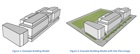
Building Model
- Portray the following elements of a building’s form:
- building height
- major massing components
- shape of the top of the building
- ornamental cornices
- roof-top mechanical sheds and penthouses
- details of the massing that deflect from the façade by more than two feet
- subterranean massing, such as underground parking, if possible
- Ideally, models of the adjoining existing structures should be included but grouped separately from the new structure.
- All faces in the model should be colored white. No exterior textures should be included. No interior partitions, window or door details should be included.
Site Plan Image
- Show how the building meets with the ground, including the edges of paved areas, parking, and landscaping with garden elements.
- The site plan image should extend beyond the limits of the project area and should show how the proposed site plan elements meet with existing walkways and streets.
Formatting Specifications
CDD can accept Building Models as SketchUp, COLLADA or KMZ format files. Most architectural modeling tools can export to these formats.
The Site Plan Image is preferred to be a JPEG, PNG or TIF format with a fine-enough resolution that the line work and text labels are clearly legible.
The preferred format for model submissions would be achieved by simply grouping the Building Model and Site Plan Image in SketchUp and exporting the selection as a SketchUp component or as a KMZ file. Alternatively, the 3D files, site plan file, and a PDF of the source material (e.g., approved set of plans) can be included in a folder and compressed into a ZIP format.
Submitting Files
Submit files to Brendan Monroe at CDD: bmonroe@cambridgema.gov.
The latest version of the model may be downloaded from the Cambridge GIS 3D downloads page (cambridgema.gov/GIS/3D/3ddata). The model is available in tiled SketchUp, COLLADA, and DXF formats, as well as a seamless GIS shapefile format for use in design tools.
Use of Submitted Files
This requested submission is intended to enable the City to incorporate an accurate representation of the permitted building(s) into the citywide 3D model, which is a public resource. Submissions to the City are public records unless qualified as an exemption under the Massachusetts Public Records Law.
The City may need to modify the submitted files if necessary to be compatible with the citywide 3D model. CDD or GIS staff may contact the group submitting the requested files to review necessary modifications.
Contacts
Please contact CDD or GIS staff with any questions:
CDD: Brendan Monroe, bmonroe@cambridgema.gov
GIS: cambridgema.gov/GIS/contactforms/GIS