East Cambridge - Neighborhood 1
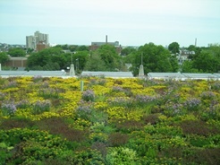
Police Station Green Roof

East Cambridge, a neighborhood of about seven thousand residents, is bounded by Somerville to the north, the Charles River to the east, the Boston & Albany Railroad tracks to the west, and Kendall Square to the south. East Cambridge became a working class neighborhood with a sizable immigrant population in the mid-nineteenth century, with the beginning of the industrial revolution. For a many decades this neighborhood included a number of major manufacturing and industrial businesses. Since the early 1980’s major changes in land use have transformed large manufacturing and industrial areas into commercial and retail developments with a vibrant business and commercial center.

The central part of the neighborhood, one of the oldest residential neighborhoods in Cambridge, has a major commercial and transit center at Lechmere Square, with a longstanding neighborhood retail strip to the west along Cambridge Street. Middlesex County District Court facilities are also located near Lechmere Square. The southern part of East Cambridge, a former industrial area adjacent to the Massachusetts Institute of Technology, it now serves as home to many offices and research labs, as well as several large apartment buildings. Kendall Square is the major commercial and transit center in the southern section. The Charles River waterfront contains hotels, luxury apartment buildings, high-tech businesses, a regional shopping mall, and the Boston Museum of Science. The upper part of East Cambridge, lying to the north of the Monsignor O’Brien Highway and bordering Charlestown and Somerville, is an underdeveloped area known as “North Point”, which is permitted for redevelopment over the coming decades.

East Cambridge Neighborhood Map

East Cambridge 3D Map

East Cambridge Statistical Profile


The objective of a neighborhood study and subsequent updates is to identify planning issues in the neighborhood and articulate recommendations to address those issues. The study recommendations are the key part of the neighborhood study and updates. The recommendations are used not only to guide neighborhood planning efforts for the Community Development Department but in many cases are included as work items for other City departments when appropriate.

2006 NEIGHBORHOOD STUDY UPDATE

The Community Development Department conducted the East Cambridge Neighborhood Study Update during 2005 and 2006. At two public meetings, staff discussed planning work that occurred in the neighborhood since completion of the original East Cambridge Neighborhood Study in 1989 and heard from residents about their current planning concerns.

In November 2006 the Department published the East Cambridge Neighborhood Study Update: Summary, Recommendations, and Action Plan, which summarizes the discussion from the neighborhood meetings and lists new and old recommendations, along with reports on the progress made in addressing each recommendation.

1989 NEIGHBORHOOD STUDY

The original neighborhood study was conducted in 1988 and issued in 1989.

If you would like to receive a printed copy of the report, please contact Tracey Joyce in the Community Planning division at 617/349-4650 or tjoyce@cambridgema.gov.

  • Canoe's at Broad Canal

    Broad Canal in the afternoon.

  • Cambridge Street corridor.

    Cambridge Street corridor.

  • Lechmere Canal Park

    Lechemere Canal Park in late summer.

  • Typical residential street in East Cambridge.

    Typical residential street in East Cambridge.

  • Costa Lopez Taylor Community Gardens

    Community gardens at Costa Lopez Taylor Park.

  • Costa Lopez Taylor Park in full bloom.

    Costa Lopez Taylor Park in full bloom.

Parks in Development

Eastern Cambridge - Kendall Square Parks Project 

  • Triangle Park
  • Binney Street Park
  • Citywide

    Map of Cambridge Parks and Playgrounds

    Neighborhood Planner: Gary Chan, gchan@cambridgema.gov, 617/349-4603,