Esri Shapefile
GIS File Name
Camb3D_Active_MP_SHP.zip
Last Modified
April 8, 2023
Format
Esri Shapefile Multipatch Features
Description
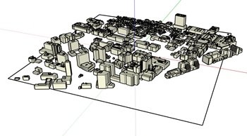
The City of Cambridge, Massachusetts, Geographic Information System (GIS)
City-Wide 3D project provides a detailed three-dimensional model including the terrain, ground plan and buildings of the city.
The buildings layer was developed from stereo photogrammetric methods, capturing the roof-details larger than 1 Meter with a precision of about 10 centimeters. The roof-print of the building is projected to a terrain model to create a 3D building volume. This dataset can be opened with GIS Applications by Esri, such as ArcGIS Pro.
Purpose
This buildings model is useful as a visual reference for the shape and location of buildings. It can be used as a setting for design studies, and solar roof analysis.
Download Citywide Data
Camb3D_Active_MP_SHP.zip
Sources
The Buildings and Bridges 3D layers were created using aerial imagery from various flyovers between 2010 to 2023. These models were built using photogrammetric processing by CyberCity 3D and in some cases enhanced or supplemented by in-house editing. The buildings in bridges have a level of detail (LOD) of 2.0 or better.
Coordinate System
NAD 1983 StatePlane Massachusetts Mainland FIPS 2001 Feet