Ground Plan JPG
GIS File Name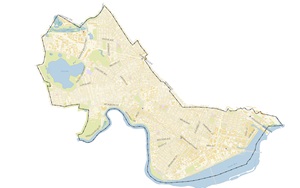
Citywide: CAMB3D_Citywide_GroundPlan.jpg
Tiled: CAMB3D_[Tile Name (ex: E-2)]_2025_Groundplan_JPG
Format
JPG Image
Updated
2025
Description
The City of Cambridge, Massachusetts, Geographic Information System (GIS) City-Wide 3D project provides a detailed three-dimensional model including the terrain, ground plan and buildings of the city.
This image can be opened with GIS Applications by Esri, such as ArcGIS Pro and used as a basemap for the Citywide Buildings.
Purpose
This image is useful as a visual reference for the city and location of buildings.
Download Data
Citywide
CAMB3D_Citywide_GroundPlan.jpg
Tiled Data
View 3D Data Download Map
Coordinate System
Tile Scheme and Coordinate System:
The 5000 foot tile scheme is designed to facilitate exchange of precise georeferenced models and context information among a variety of authoring and presentation tools. The tile network covers the greater Boston area.
State Plane coordinates are offset to keep all coordinates within limits inherent in most 3D design tools.
Projected Coordinate System:
State Plane Massachusetts Mainland (Feet), North American Datum of 1983.
Vertical Datum:
North American Vertical Datum, 1988 (NAVD 88) Feet (Height)
Coordinate System Origin (Offsets)
- X: 731,100MA State Plane Feet
- Y: 2,902,900 MA State Plane Feet
- WGS84 Longitude: 71.223391 W
- WGS84 Latitude: 42.213379 N
- Elevation: 0
- Rotation to align with True North: Clockwise 0.34 Degrees.