Ortho JPG
GIS File Name
CAMB3D_[Tile Name (ex: E-2)]_2025_OrthoPhoto_JPG
Updated
April 10, 2025
Format
JPG image
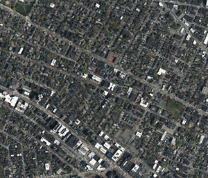
Description
The City of Cambridge GIS maintains a 3D model of the city as a visualization and analytical tool for understanding ideas related to the future of the City. The Cambridge 3D model is constructed of several components: Terrain, Ground plan, and 3D models of buildings and bridges. Each of these components is shared in formats intended to facilitate collaboration between diverse communities who have an interest in understanding places in the city as they have changed or as they may be changed.
The 2025 aerial photo is useful as a visual reference for the ground conditions as it relates to terrain and buildings. The image has a resolution of 3 inches per pixel. Along with the planimetric ground plan, these photographs may be useful for discovering updated conditions or details not included in the vector-based planimetric ground plans.
Purpose
The City of Cambridge GIS maintains a 3D model of the city as a visualization and analytical tool for understanding ideas related to the future of the City. The Cambridge 3D model is constructed of several components: Terrain, Ground plan, and 3D models of buildings and bridges. Each of these components is shared in formats intended to facilitate collaboration between diverse communities who have an interest in understanding places in the city as they have changed or as they may be changed.
Download Tiled Data
View 3D Data Download Map
Sources
Spring 2025 flight by Nearmap
Coordinate System
Tile Scheme and Coordinate System:
The 5000 foot tile scheme is designed to facilitate exchange of precise georeferenced models and context information among a variety of authoring and presentation tools. The tile network covers the greater Boston area.
State Plane coordinates are offset to keep all coordinates within limits inherent in most 3D design tools.
Projected Coordinate System:
State Plane Massachusetts Mainland (Feet), North American Datum of 1983.
Vertical Datum:
North American Vertical Datum, 1988 (NAVD 88) Feet (Height)
Coordinate System Origin (Offsets)
- X: 731,100MA State Plane Feet
- Y: 2,902,900 MA State Plane Feet
- WGS84 Longitude: 71.223391 W
- WGS84 Latitude: 42.213379 N
- Elevation: 0
- Rotation to align with True North: Clockwise 0.34 Degrees.
Usage Notes
Each image is clipped exactly to the frame for each tile of the city-wide grid, making these images very easy to register and apply as a material on tiled terrain models in .OBJ or Sketchup format.
To drape this image on the terrain in SketchUp, use the eye dropper in the Materials window to select the terrain material, then, using the Material Edit tab, use the browse button to find the appropriate image file.