Time-Separated Turns
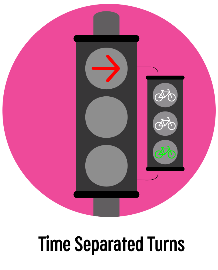 |
What are Time-Separated Turns? Time-Separated Turns are traffic signal patterns that give people driving, biking, and walking their own dedicated time to move through an intersection. Instead of right or left-turning drivers trying to find safe gaps in traffic, they have separate, dedicated time to make the turn. This approach requires some additional signal time, dedicated turn-only lanes, and traffic signals with directional arrows.
Where are Time-Separated turns practical?
Time-Separated Turns can only be implemented at signalized intersections with turn lanes. Then, we prioritize intersections where many drivers make turns, that have a history of serious turning vehicle crashes, or have high volumes of pedestrians and cyclists.
Benefits:
- Fully separates bike and pedestrian movements from turning vehicles movements
- Eliminates conflicts between drivers turning left and drivers proceeding straight through (or right)
- Can improve intersection efficiency by clearing queues of turning vehicles faster, especially when paired with detection to adjust time to the number of turning vehicles
|
Time-Separated Turns in Cambridge, MA:
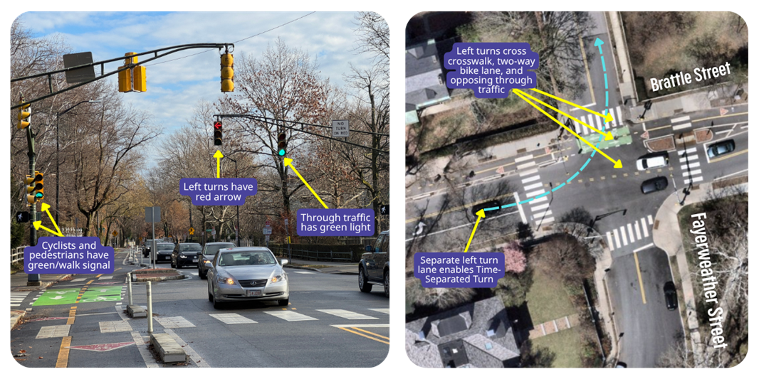
Intersection Photographed: Brattle St at Fayerweather St
Why Here?
A driver making a left turn onto Fayerweather St from Brattle St would have to find gaps in oncoming vehicle traffic, find gaps in two directions of bike traffic, and yield to pedestrians in the crosswalk if they didn’t get their own left turn phase. The Time-Separated Left turn follows the traffic safety principle of accounting for human error – instead of hoping all left-turning drivers judge multiple gaps perfectly, we allocate time in the signal cycle to stop all traffic in their path and let them make their turn more easily.
Corner Islands
 |
What are Corner Islands? Corner Islands are small raised or paint-marked areas at intersections. The islands are placed so that right-turning drivers follow a slower, tighter, and safer path. Tighter turns are slower and improve visibility between drivers and people in crosswalks and bike lanes. On busier streets, corner islands need to be in places where buses and trucks won’t run over them.
Where are Corner Islands Practical?
Corner islands can be implemented at signalized and unsignalized intersections. We prioritize locations with a history of serious right-turning crashes and locations where lots of drivers make right turns at higher speeds. Corner islands are often paired with other treatments to better designate spaces for people driving, walking, and biking.
Benefits:
- Limits the speed of turning vehicles.
- Provide an offset that allows vehicles a better view of cyclists and pedestrians when they are turning.
- Can provide some separation from turning drivers at signalized intersections when Time Separated Turns are not feasible.
- Improves turning driver yielding compliance at unsignalized intersections .
|
Corner Islands in Cambridge, MA: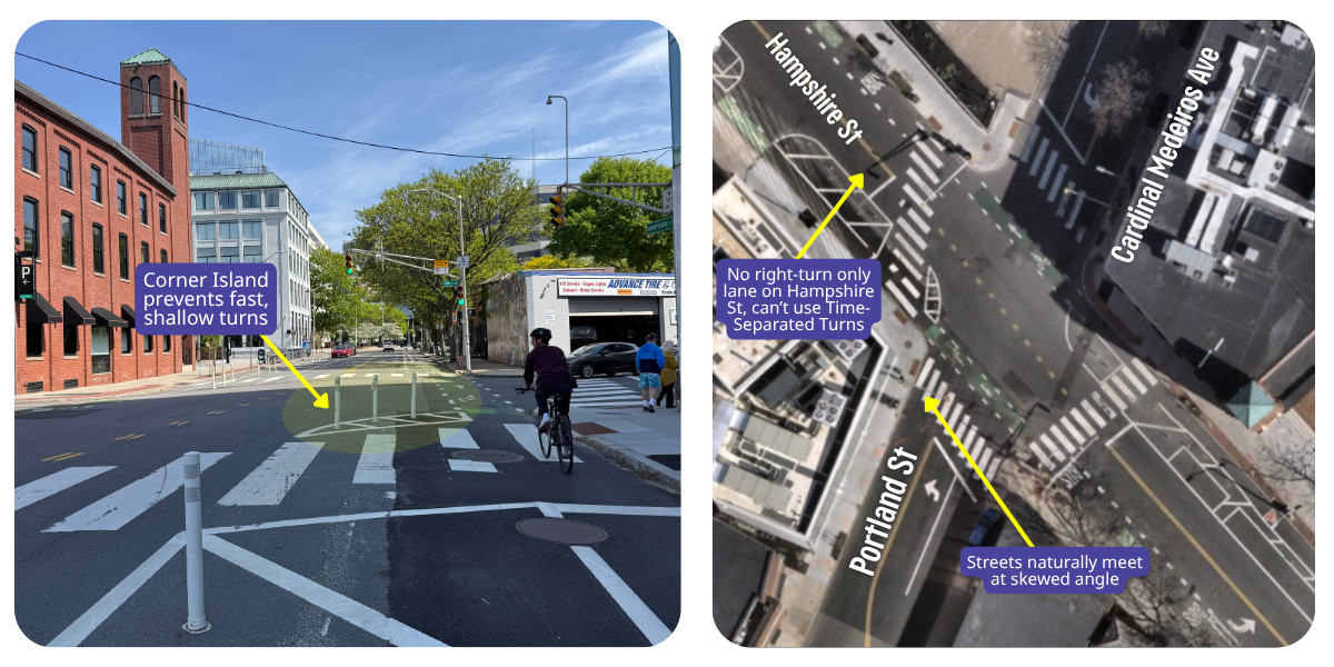
Intersection: Hampshire St at Portland St
Why Here?
There was a fatal turning crash at this intersection that highlighted the need to address the possible conflicts between turning vehicles and cyclists or pedestrians. Hampshire St doesn’t have space for a right-turn only lane to implement Time-Separated Turns. Hampshire St and Portland St also meet at a skewed angle, which allows drivers to make faster turns as compared to streets that meet at a 90-degree angle. This Corner Island guides turning vehicles to make their turn slowly and at more of a right angle, so they can see cyclists and pedestrians who have the right-of-way.
Bicycle Intersection Markings
 |
What are Bicycle Intersection Markings? Bicycle Intersection Markings are specially painted areas for cyclists approaching or within an intersection. These markings make intersections safer and more predictable for everyone on the road. There are different kinds of bicycle intersection markings:
- “Crossbikes” (dashed white bike lane extensions across an intersection) for cyclist wayfinding and driver awareness
- “Two-stage turn boxes” and “Bike boxes” (green-colored boxes) for designating space for cyclists to wait to turn or wait for their signal
- “Forward queuing areas” (marked bike lanes ahead of vehicle stop lines) to help position cyclists outside of drivers’ blind spots
Bicycle Intersection Markings mark where cyclists will most commonly be expected. However, drivers should be aware of cyclists in all areas of an intersection.
Where are Bicycle Intersection Markings Practical?
Bicycle Intersection Markings are most useful when cyclists pass through an intersection or are expected to do so in the future. If one of the streets at an intersection has a bike lane or is in Cambridge’s Bike Network Vision, we will consider different types of bike intersection markings based on the context of the intersection.
Benefits:
- Indicates a bikeway crossing is present and guides people on bicycles through intersections.
- Makes challenging maneuvers easier and more intuitive for cyclists.
- Positions cyclists ahead of drivers so that they are more visible.
- Can reduce cyclist usage of sidewalks and crosswalks as a means of avoiding areas they perceive as unsafe.
|
Bicycle Intersection Markings in Cambridge, MA:
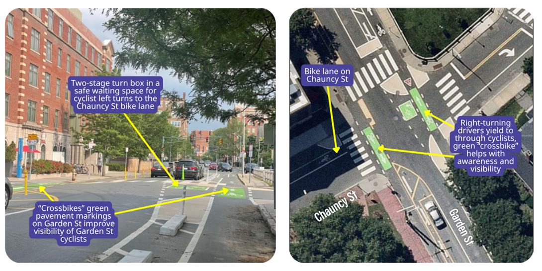
Intersection Photographed: Two-Stage Turn Box and Crossbikes at Garden St at Chauncy St
Why Here?
Garden St and Chauncy St are both in the Bike Network Vision and both have bike lanes. This intersection is unsignalized, so a cyclist turning left from the bike lane on Garden St into the bike lane on Chauncy St needs a space to wait for a gap in traffic. The two-stage turn box provides a safe spot to wait, while the crossbike clarifies the path for through cyclists. The crossbikes also help make turning drivers on Garden St aware of the presence of cyclists.
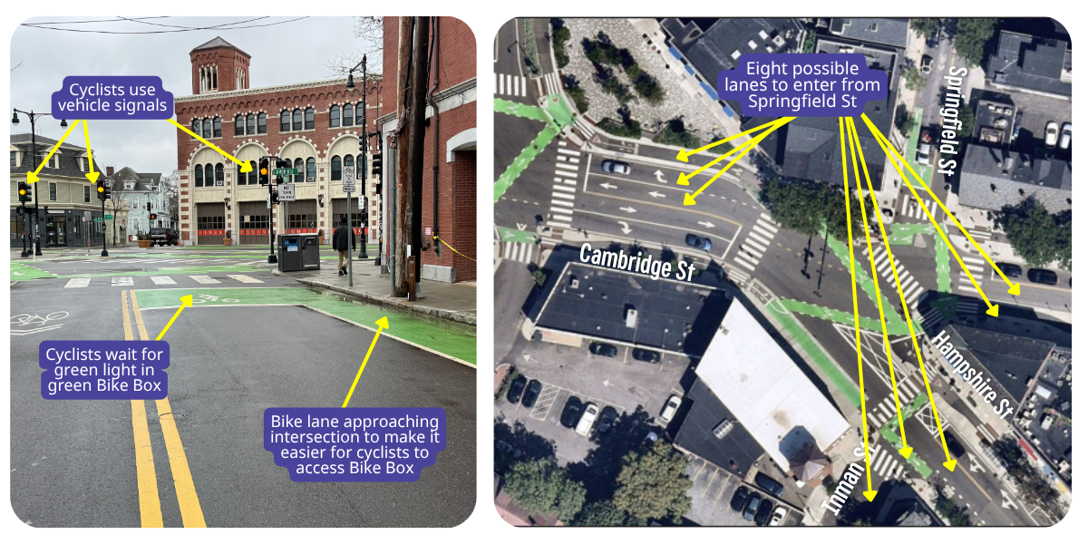
Intersection Photographed: Bike Box on Springfield St
Why Here?
Inman Square is a very wide intersection with lots of possible directions cyclists and drivers can go. On Springfield St, cyclists and drivers can turn right or left onto Cambridge St, left onto Hampshire St, or continue through on Inman St. With so many possible options, it is useful to have cyclists positioned ahead of drivers so they can be seen by drivers behind them.
Head Starts (Leading Intervals)
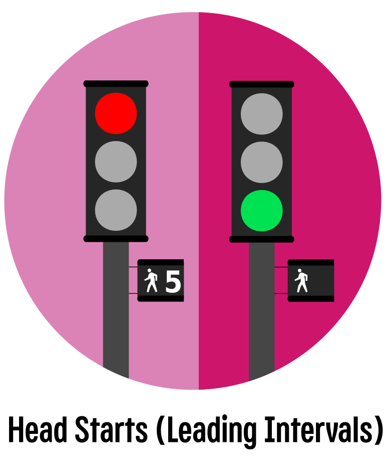 |
What Are Head Starts? Head Starts, or Leading Intervals, refer to short periods of time (a few seconds) when cyclists and/or pedestrians can start crossing before any driver gets a green light. Because Head Starts allow pedestrians and cyclists to enter the intersection before vehicles, this gives them priority over drivers making turns, who are required to yield to through cyclist traffic and pedestrians.
Where are Head Starts Practical?
Our policy is generally to have Pedestrian Head Starts implemented at all signalized intersections in Cambridge that do not have Time-Separated Turns. We will prioritize Bike Head Start at locations that have a history of bicycle-turning vehicle crashes but do not meet criteria for Time-Separated turns. Head Starts are often used with Corner Islands to indicate priority for pedestrians and cyclists with both time and distance (space).
Benefits:
- Allows pedestrians and cyclists get near the middle of the intersection, so they are clearly visible to drivers.
- Encourages turning drivers to comply with proper yielding.
- Can provide partial separation from turning drivers when Time-Separated Turns are not feasible.
|
Head Starts (Leading Intervals) in Cambridge, MA:
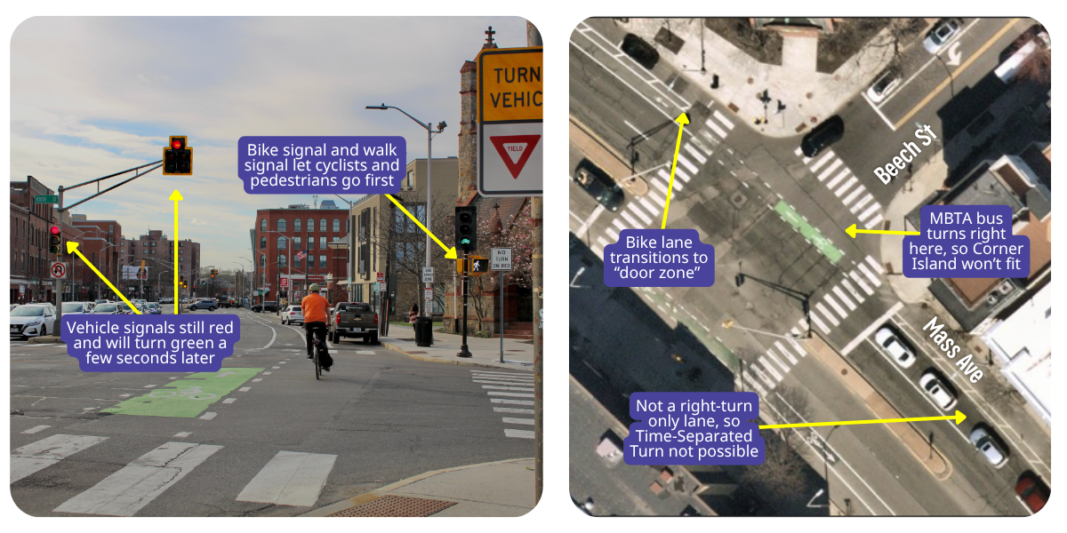
Intersection Photographed: Mass Ave at Beech St
Why Here?
Since there’s no right-only turn lane on Mass Ave at this location, Time-Separated Right Turns cannot be implemented. The MBTA Route 96 bus turns right onto Beech St from Mass Ave, so a Corner Island is impractical. This location is also where a separated bike lane ends. This means that the buffer between the travel lane and the bike lane on Mass Ave ends at this intersection. In order to create a safer intersection for people walking and biking, there is a Bike Head Start and the typical Pedestrian Head Start here.
Raised Centerlines
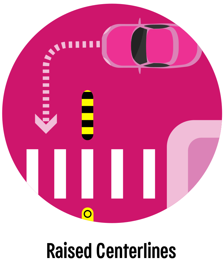 |
What Are Raised Centerlines? Raised Centerlines are small portions of the double yellow centerline that have raised traffic control devices. Quick-build raised centerlines use low-profile “bumblebee” devices and are often paired with yellow flex posts to enhance the visibility of the centerline, discourage drivers from crossing it at undesirable locations, and reinforce the appropriate path for making safer turns. Most drivers of passenger vehicles avoid running over the traffic control devices and will instead make their turns in an intentional, controlled way. The flex posts are placed in areas that are unlikely to be run over by any vehicle, while the bumblebees are placed in a way that allows the back wheels or trailers of larger vehicles to run over them without damage to the vehicle or the device.
Where are Raised Centerlines Practical?
Raised Centerlines can be implemented at signalized and unsignalized intersections. We prioritize locations that have a history of serious crashes due to turning vehicles but do not meet the criteria for Time-Separated Turns. At intersections without Time-Separated Turns, Raised Centerlines often make sense when streets meet at unusual angles or have large amounts of unmarked asphalt. Installing a Raised Centerline deters drivers from making fast, shallow turns and guides drivers into the correct receiving lane.
Benefits:
- Reduces the speed of turning vehicles, especially left-turning vehicles
- Helps guide drivers along a safe turning path
- Can be designed based on the typical turn pattern of a passenger vehicle
|
Raised Centerlines in the Area:
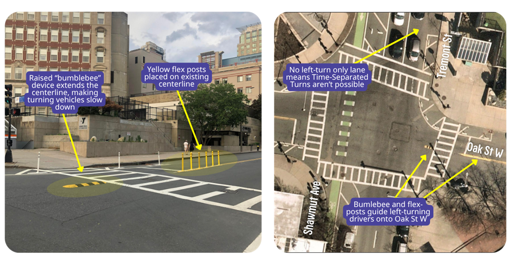
Intersection Photographed: Oak St West at Tremont St, City of Boston
Why Here?
In this example on Tremont St in Boston’s Chinatown near the Wang YMCA, the road doesn’t have a left turn lane or signal, meaning drivers make left turns across the pictured crosswalk while pedestrians have a walk signal to cross it. This is an especially important location for slowing left-turning drivers because of its proximity to a school, the YMCA and a subway station entrance.
Daylighting (Clear Corners)
 |
What is Daylighting? Daylighting, or Clear Corners, refers to areas close to an intersection where parking is restricted to ensure clear views of other people driving, biking, or waiting to cross the street. In most cases, parking is already restricted by law in these areas, but the addition of a No Parking Sign, diagonal pavement markings, and flex posts can prevent illegal parking and loading in these critical areas. When the Daylighting area is extended into the intersection itself, it also creates a Curb Extension or Crossing Island.
Where is Daylighting Practical?
Daylighting is only possible on streets that have a parking lane that extends to the intersection – if the parking lane changes to a turn lane, for example, there will not be any room for Daylighting. Daylighting is primarily a way to improve mutual visibility. We prioritize intersections that have poor visibility or unusual geometry for our full treatment (flex posts and pavement markings as well as signs). We also prioritize Daylighting at intersections with parking-protected bike lanes to ensure that cyclists aren’t hidden from view by parked vehicles when approaching an intersection.
Benefits:
- Improves visibility for all roadway users
- Reinforces legal parking restrictions without need for police enforcement
- Help first responders in larger vehicles make turns without hitting parked cars
|
Daylighting in Cambridge, MA:
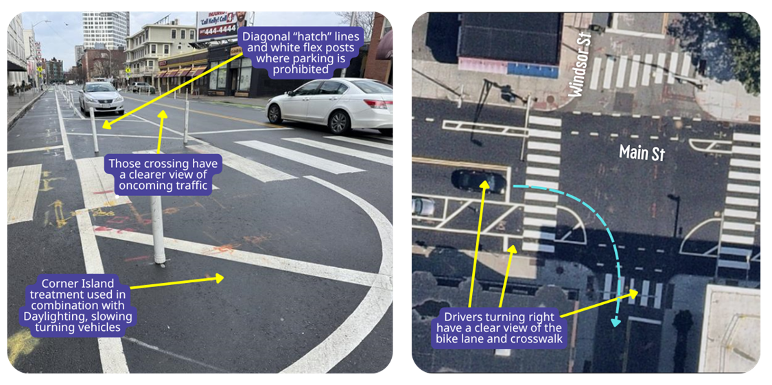
Intersection Photographed: Main St at Windsor St
Why Here?
Although Main St at Windsor St is a signalized intersection, right-turning drivers need to see the bike lane and the crosswalk to judge when they can safely turn onto Windsor St. The Daylighting on the south side of Main St helps make sure that nobody can park too close to the intersection and obstruct a driver’s view. Although it’s not marked with tan paint, this Daylighting is also creating a Crossing Island where pedestrians can wait once they have crossed the bike lane.
Curb Extensions and Crossing Islands
 |
What Are Curb Extensions and Crossing Islands? Curb Extensions and Crossing Islands are places where pedestrians can wait to cross in an intersection. Curb Extensions are extensions of the sidewalk, while Crossing Islands are between lanes of traffic. Both are used to shorten the length of crosswalks and improve visibility, making crossing safer and easier for pedestrians. Crossing Islands also provide space to wait in between crossing lanes of traffic, so that pedestrians do not have to judge multiple gaps in traffic at one time. Because changes to the curb can affect underground utilities, they can be time-intensive and costly to design and install. Quick-Build Curb Extensions and Crossing Islands are faster and cheaper options that use paint and sometimes flex posts.
Where are Curb Extensions and Crossing Islands Practical?
Curb Extensions and Crossing Islands, similar to Daylighting, can only be implemented if there is extra space in the intersection. Extra space can come from a parking lane ending, so many locations that have Daylighting also have a Curb Extension or Crossing Island. While Daylighting is prioritized at intersections that have visibility problems, Curb Extensions and Crossing Islands are prioritized at intersections with long crossings or crosswalks across multiple lanes of traffic.
Benefits:
- Shorter crossing distance means pedestrians are in the roadway for less time
- Pedestrians standing on a Curb Extension or Crossing Island are more in the line-of-sight of drivers and have a better vantage point to see drivers
- Crossing Islands help pedestrians cross unsignalized intersections safely by providing places to wait while ensuring drivers and cyclist yield.
|
Curb Extensions and Crossing Islands in Cambridge:
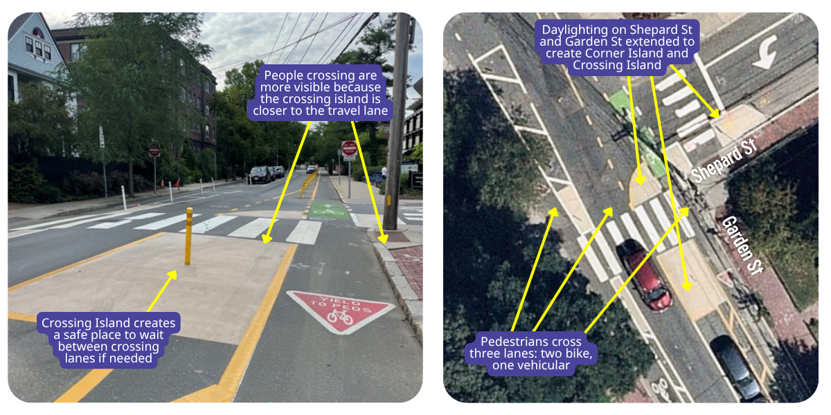
Intersection Photographed: Garden St at Shepard St
Why Here?
Although Garden St is one way for drivers, there are protected bike lanes in both directions. This means pedestrians crossing Garden St must cross three lanes of traffic in two directions. The crossing island provides a spot to wait that is not in the path of a driver or a cyclist where pedestrians can check to make sure oncoming traffic yields to them before proceeding. The crossing island is also located in a spot that is easily seen by drivers on Garden St, drivers on Shepard St, and cyclists on Garden St. Notice the Daylighting on both Garden St and Shepard St has been extended to create a Crossing Island and a Corner Island, providing better visibility and safe turning improvements to this intersection.