

October 2025
The project design has ended. The Department of Public Works will maintain a webpage dedicated to construction updates. Please use this link to visit the Department of Public Works webpage for construction related updates. The City will send out newsletters with construction related updates to everyone subscribed to the project email list. Please sign up for the e-newsletter below where it says Stay In The Loop.
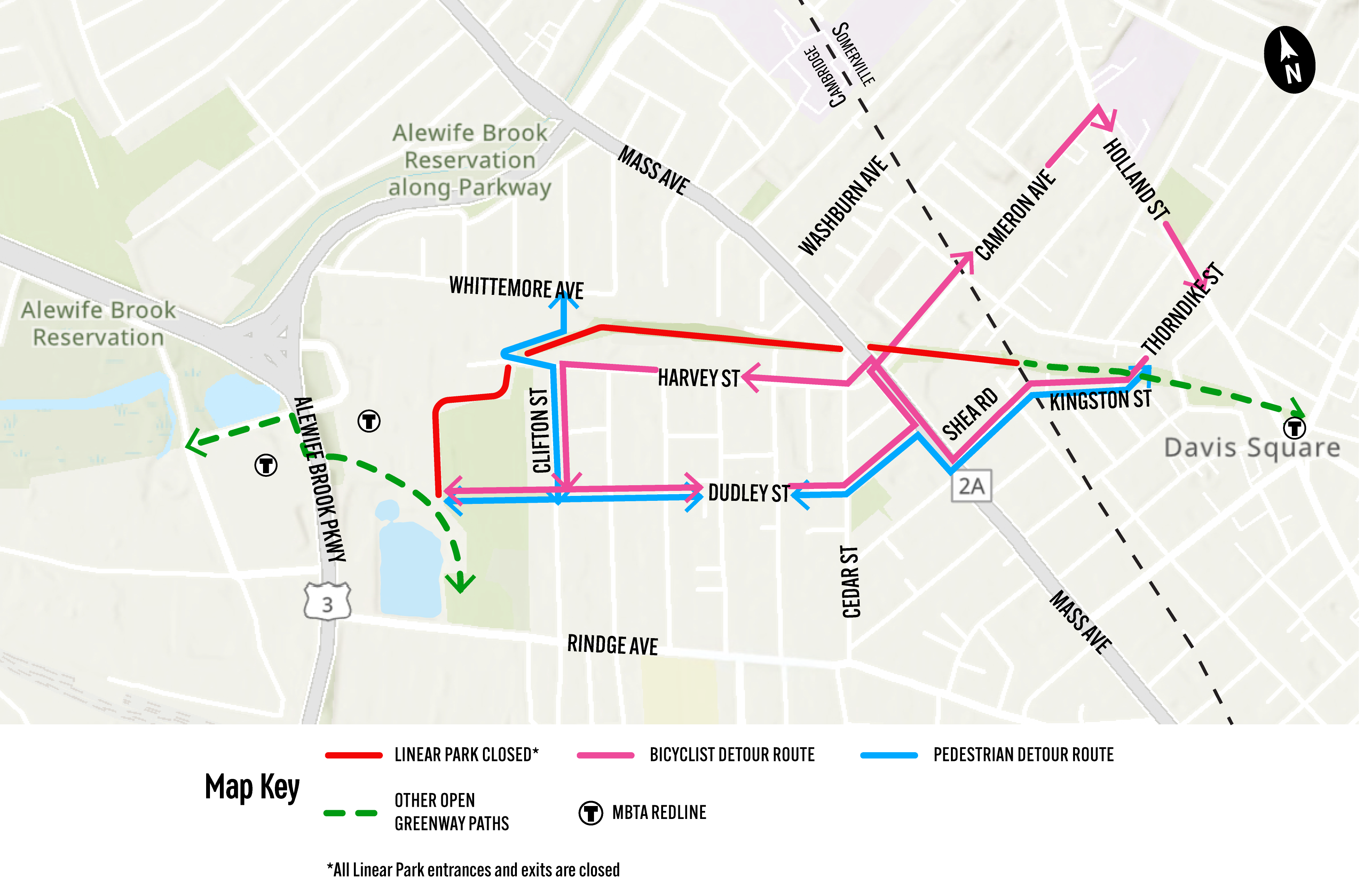
Path Detour Routes
Please use this lick to view the pedestrian & bicycle detour map.
Bicyclists traveling from the Russell Field area east towards Davis Square can use the following signed detour route:
- East on Dudley St – the one block of Dudley St from Cedar St to Mass Ave will be flow reversed. Starting October 23, 2025, motor vehicles and cyclists will travel towards Mass Ave.
- Left on Mass Ave – Bicyclists can use the pedestrian push button to cross Mass Ave and go north to Cameron Ave.
- Right on Cameron Ave.
- Right on Holland St.
- Right on Thorndike St.
- Then rejoin Linear Park / Community Path at the Thorndike St entrance in Somerville.
Bicyclists traveling from the Davis Square area west towards Alewife Station can use the following signed detour route:
- Turn left off the Somerville Community path onto Thorndike St.
- Right onto Kingston St.
- Continue straight onto Shea Rd – Shea Rd will have parking temporarily restricted on the north side to create a contraflow bike lane. Cones will be in place to create dedicated street space for bicyclists.
- Right on Mass Ave – Bicyclists can either utilize the green painted area on Cameron Ave, or travel across the north bound lanes and utilize the left-hand turn lane shared with motor vehicles.
- Left on Harvey St.
- Left on Clifton St.
- Right at the intersection of Dudley St and Russell Field to rejoin Linear Park at Russell Field and access Rindge Ave, the Minuteman Path, or the Fitchburg Cut Off path.
Pedestrians traveling east or west between the Russell Field area and Davis Square can use Dudley St, the Mass Ave pedestrian push button crossing, Shea Rd, Kingston St, and Thorndike St.
Pedestrians traveling north south in the Whittemore Ave / Clifton St neighborhood can use a signed detour route that travels along the edge of Linear Park, near the dead end of Harvey St, to access Whittemore Ave.
February 2025 Meeting Materials
Thanks to all those who attended the February 2025 open house. Please use the following links to download or view meeting materials from the open house event.
1- Vision, Goals, Schedule, Key Park Upgrades
2- Key Themes from Engagement, Why Widen, How We're Protecting Trees
3- Park Zones, Incorporating Play, Precedent Photos
4- Detour Routes During Linear Park Closure
5- Rendering at Cedar St
6- Rendering in Mid Park Area
7- Rendered Park Plans 20 Scale
8- Rendered Roll Plan 40 Scale
November 2024 Update
Linear Park Draft Construction Plans
Please use the following links below to download PDF versions of the different pieces of the construction plan set. Because the file sizes of the entire planset is so large, we’ve broken them down into more manageable pieces of the overall plan set.
- Construction Plans - These plans show demolition notes, paved main path area, stonedust secondary path areas, and other park elements like boulders, benches, lighting, and water fountains.
- Landscape Materials Plans - These plans with the materials legend show the different site furnishings, site lighting, landscape elements, fences, and stone walls.
- Landscape Planting Plans - These plans show the different grasses, shrubs, trees, and irrigated ornamental beds.
- Landscape Soils Plans - These plans show the soils that will be amended for healthier plantins and some areas where soil will be replaced because it is in poor health.
- Cost Estimate - This document includes a detailed breakdown of cost for each item needed to refurbish and reconstruct the park and pathway.
What are some things the City is doing to respond to previous comments about the Linear Park Redesign project?
Tree removals: We are not removing any healthy mature trees. We are removing 5 deteriorated Cherry trees which will be replaced with Cherry trees.
Tree and root protection: We have standard tree protection fencing details incorporated into drawings and specifications. We're taking a belt and suspenders approach to trunk and root protection: we've included language to limit the contractors access to critical tree root zones. We've modified details to limit disturbance and address tree and root protection issues. Specifications and additional notes were added to require oversight and approval from City staff before earthworks or excavation. And we're requiring the Contractor to prepare and submit monthly tree inspections. Any issues must be reported immediately with proposed remedial actions. Finally, we are requiring regular watering and deep root fertilization to minimize stress on the existing trees.
Soil improvements:
- Air spading / decompaction
- Amending soil
- Soil replacement in limited locations (closer to Somerville line)
Infrastructure installation: All irrigation water lines and electrical conduit are in a shared trench to minimize disruptions to roots. The trench is located under the paved path. Some modifications to bench and trash can locations were completed to minimize disruptions to roots.
Design flexibility to field conditions: Contractor required to work with City staff if tree, root, or other conflicts will require slight modifications to plans.
City construction phase oversight: A Dept. of Public Works Clerk on site every day overseeing construction. City Forestry department / arborists are available for review and decision making in the field. Weekly construction coordination meetings will keep everyone on top of recent activity and what to expect for the week ahead.
If you have any problems downloading these plans, or want a link to download the entire large planset all together, which includes some information on specifications, and civil details, please email Charlie Creagh at: ccreagh@cambridgema.gov.
May 2024 Update
As a follow up to requests to have more information on why the City is proposing a slight widening to 14' along Linear Park, we summarized research from three publications by the U.S. Department of Transportation and the American Association of State Highway Transportation Officials (AASHTO). To view the short slide deck, please use this link. Widening to 14' in locations where we have sufficient space will reduce conflicts between pedestrians and bicyclists, improve the path user experience, and make it more comfortable for all path users.
Past Meetings
City Council Neighborhood and Long-term Planning, Public Facilities, Arts and Celebrations Committee - November 15, 2023
- To view a PDF of the meeting presentation, please use this link.
- This presentation discussed ley themes from public engagement, how we used public input to craft the vision for the project, the ways we used that vision to create design plans, and how we are ensuring the continued protection of trees
Committee on Public Planting - October 11, 2023
- To view a PDF of the meeting presentation materials in a PDF, please use this link.
- This CPP meeting reviewed many of the items presented at the June public meeting and reviewed the October 2023 updated draft design plans.
Advanced Design Public Meeting #3 - June 8, 2023
- To view a PDF of the full roll plan of the design plans, please use this link.
- To view the meeting presentation materials in an accessible PDF, please use this link
- To view the video recording of the presentation and the questions asked and answered after the presentation, please use this link and case-sensitive passcode: M42+O+x9
- To view the comments, questions, and answers, you can see the PDF report here
Conceptual Design Public Meeting #2 - November 16, 2022
- To view the meeting presentation materials in an accessible PDF, you can see the slide deck here
- To view the comments, questions, and answers, you can see the PDF report here
- To view the zoom poll questions about preferences for different design options, you can view the brief slide deck here
Introductory Public Presentation #1 - June 7, 2022
- To view the pre-recorded portion of the presentation, please use this link to open the YouTube video recording: https://youtu.be/gb3BTRQxBA8
- To view the meeting presentation materials in an accessible PDF, You can view a PDF of the slides here.