U.S. flag

An official website of the United States government

Official websites use .gov
A .gov website belongs to an official government organization in the United States.

Secure .gov websites use HTTPS
A lock ( ) or https:// means you’ve safely connected to the .gov website. Share sensitive information only on official, secure websites.

Hero Photo

Central Square Safety Improvement Project

The City of Cambridge plans to install separated bike lanes in Central Square on Mass Ave between Inman St and Sidney St.


The Central Square Safety Improvement Project will:
​

Change the layout of the street with quick-build materials: new pavement markings, traffic signs, and flex posts.

Add separated bike lanes to make it safer and more comfortable to bike to homes, businesses, schools, and other destinations in Central Square.

  • Move bike lanes to be next to the curb.
  • Add white flex posts to physically separate them from moving vehicles.

Reduce on-street parking:

  • About 25% of parking will be removed.
  • Most of Central Square will retain parking on at least one side of the street. Some sections will have parking on both sides, as exists today.
  • We will work with businesses and residents to identify the best locations and regulations for the remaining parking and loading spaces.
     

These changes will help us meet the requirements of the Cambridge Cycling Safety Ordinance, support our Vision Zero goal to eliminate crashes resulting in fatalities and serious injuries, and bring us closer to realizing the Cambridge Bicycle Network Vision.
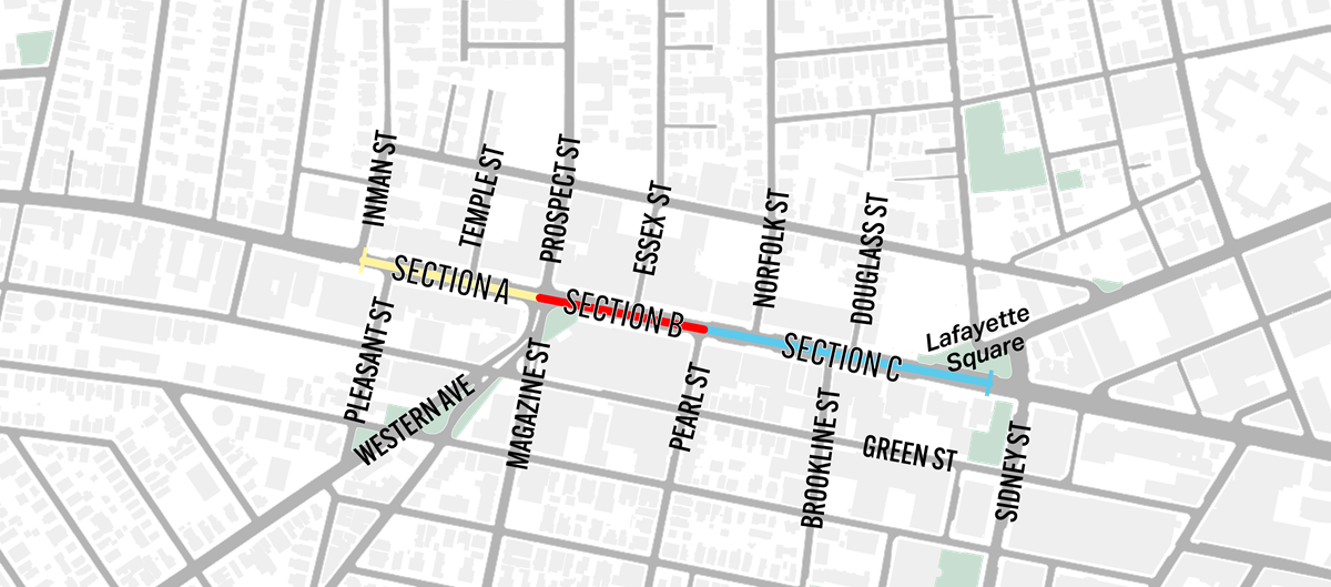
Project Sections

Map dividing the Central Square Safety Improvement Project along Massachusetts Avenue into three sections. Section A, shown in yellow, extends from Inman St Street to Prospect Street. Section B, shown in red, extends from Prospect Street to Pearl Street. Section C, shown in blue, extends from Pearl Street through Central Square to Sidney Street/ Lafayette Square.


Section A (We're here)
Inman Street to Prospect Street
Installation will begin in late 2026.
Installation Timeline: 2027

Project Status: Underway

Section B
Prospect Street to Pearl Street
Installation will not begin until after the MBTA's Central Square Station Renovation.
Installation Timeline: 2029
Project Status: Not yet started.
Section C (We're Here)
Pearl Street to Sidney Street
Installation will begin in 2027.
Installation Timeline: 2027
Project Status: Underway.

Plans

Project Plans are not yet available. 

Get Involved

We want to hear from you! 

Attend a Community Meeting

Meetings will take place in November and December of 2026 to introduce the project and share draft designs. More information coming soon!

Comment Form

If you have general comments or feedback on the project, please fill out our Central Square Safety Improvement Project Comment Form and share how you currently travel on Mass Ave. 

Comment Form

Set up a 1:1

Our project team is happy to meet with businesses, residents, organizations, and groups. Reach out to schedule a phone call, video chat, or in-person meeting by emailing us or calling 617-349-9162.

Email Project Team

Upcoming Events

November 12, 2026: Virtual Information Session

More information will become available soon. Sign up for email updates or check back on the project page for updates. 

December 2, 2026: In-Person Open House

More information will become available soon. Sign up for email updates or check back on the project page for updates. 

Outreach Materials

Project Emails

Sign up for email updates for this project and be the first to know about updated designs, meetings, and installation progress. 

Business Outreach

The project team is meeting with businesses throughout the design process.

This includes meetings with the Central Square Business District (BID). 

  • August 2026: Met with the Central Square Business District
  • September 2026: Started business outreach collaboration with Community Development

Project Introduction: September 2026

In September 2026, we will:

  • Sent X postcards to addresses in the project area. Click here to view.
  • Post A-frames with project information along Mass Ave. Click here to view.
  • Post laminated signs with project information on street signs in the project area.
    • Click here to view signs with meeting information.
    • Click here to view signs with more detailed project information.
  • Hand out flyers at businesses, libraries, and other institutions along the project area. Click here to view English version.
    • Amharic translation
    • Arabic translation 
    • Bangla translation
    • Haitian translation 
    • Portuguese translation 
    • Simplified Chinese translation 
    • Somali translation 
    • Spanish translation

City News Stories

Read the news stories we've published on the City of Cambridge website about the Central Square Safety Improvement Project:

  • September 2026: City of Cambridge launches Central Square Safety Improvement Project

More Project Information

Project Area Map

Project Area

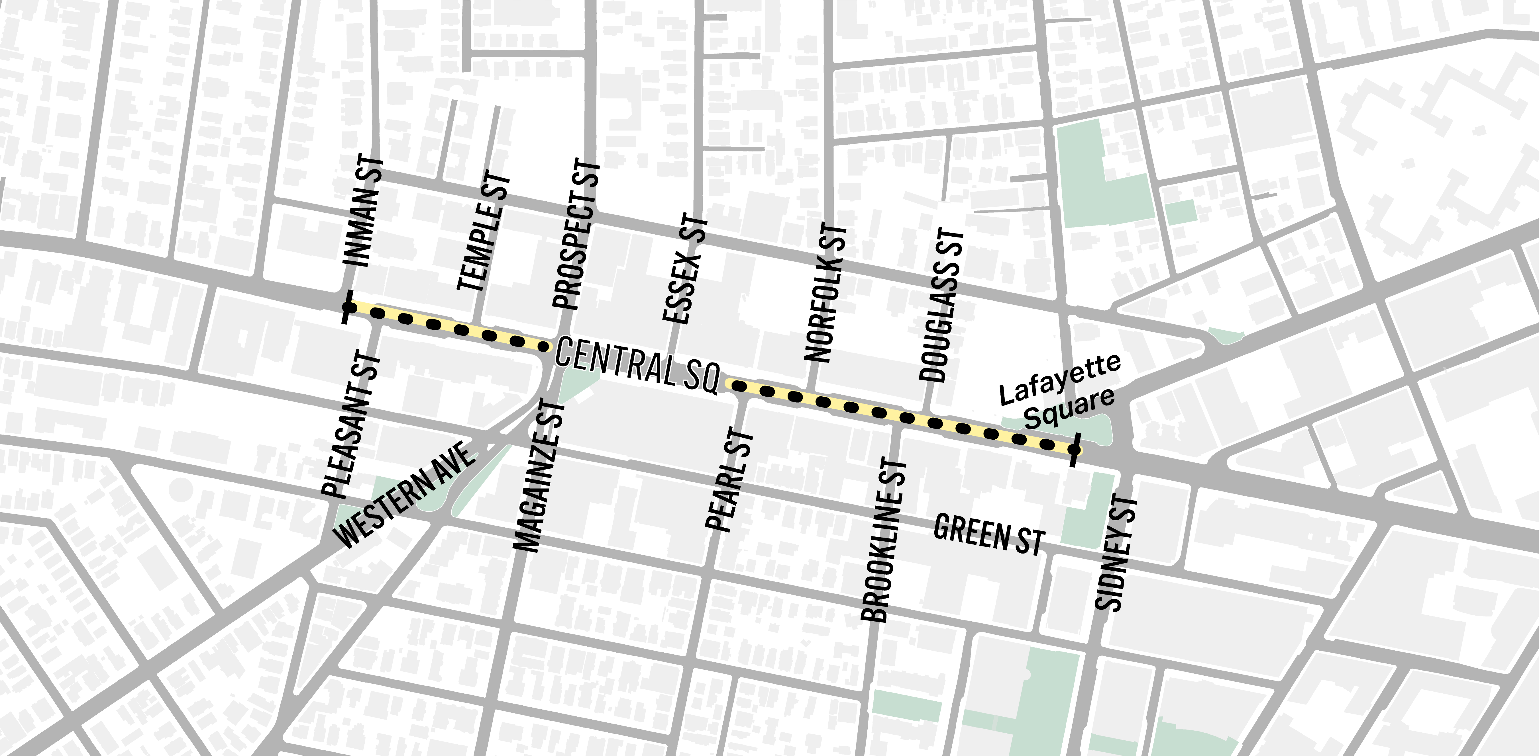
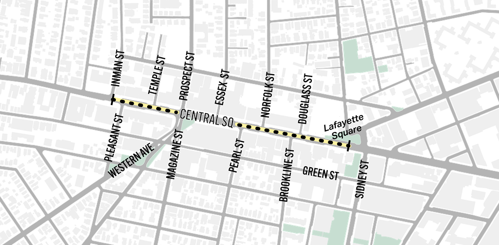
The project begins at Inman Street and ends at the crosswalk halfway between Douglass St and Sidney St.

 Map of the Central Square Safety Improvement Project area along Massachusetts Avenue, extending from Inman Street through Central Square to Sidney Street. A yellow dotted line highlights the project corridor. 

Click here for a larger version of the project map.

Policy and Design Background

The Cycling Safety Ordinance

In 2019, the Cambridge City Council passed the Cycling Safety Ordinance. The 2019 Ordinance requires the City to install separated bike lanes when:

In 2020, the Cambridge City Council passed amendments to the ordinance, requiring the installation of about 25 miles of separated bike lanes within the next five to seven years. The ordinance requires that the City install separated bike lanes on:

  • All of Massachusetts Avenue
  • Garden Street, eastbound from Huron Avenue to Berkeley Street and westbound from Mason Street to Huron Avenue
  • Broadway from Quincy Street to Hampshire Street
  • Cambridge Street from Oak Street to Second Street
  • Hampshire Street from Amory Street to Broadway
  • 11.6 miles in other locations from the 2020 Bicycle Plan

What do separated bike lanes look like?

Mt Auburn St at Holyoke St - Before and After

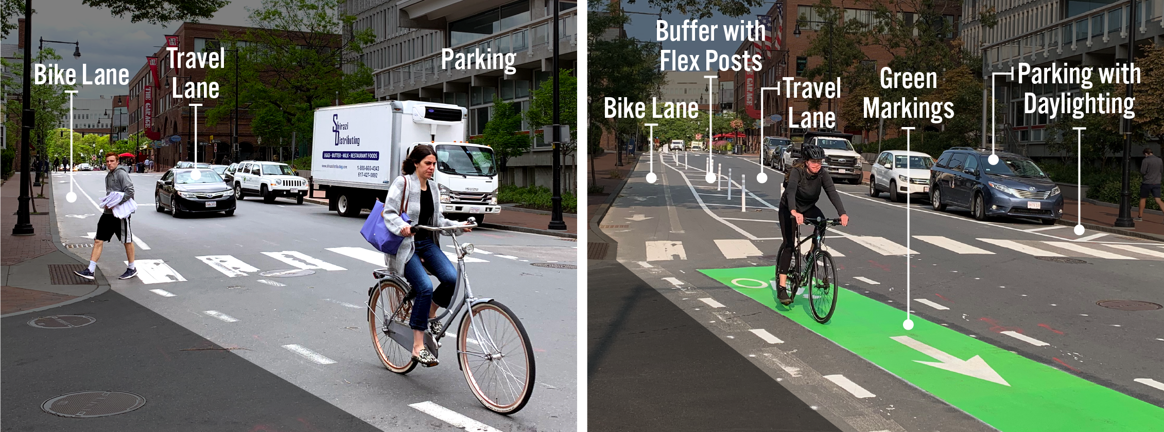
The images below show Mt Auburn St at Holyoke St before and after separated bike lanes were installed as a part of the Inner Mount Auburn Safety Improvement Project.

The left image shows Inner Mt Auburn St with a standard bike lane, travel lane, and a parking lane. The right image shows Inner Mt Auburn St with a bike lane, buffer area with flex posts, a travel lane, a parking lane, and daylighting.

Key Components of Separated Bike Lanes

  • Bike lanes create dedicated space for people who are biking.
  • Buffers (painted lines on the street) create space between people biking and people driving. They help prevent unintentional collisions that could cause serious harm to the people involved. Depending on the location, there may be a parking lane next to the buffer area. In these instances, drivers can use the buffer area to safely get in and out of the car and to load and unload items.
  • Flex posts are placed in the buffer area and serve as a vertical barrier in the buffer area.
  • Travel lanes allow space for people to drive down the street, but can be used by anyone.
  • Green markings help alert people turning from the travel lane that they should look out for people on bikes. These are generally installed at intersections and across driveways.
  • Parking creates space for people to store their vehicles while they are in the area. This part of the street may also be designated as loading zones, which help make it easier for delivery people to do their jobs.
  • Daylighting is when the parking lane is pulled back 20 feet to make it easier for people driving down the street and people waiting to cross the street to see each other. These areas are generally marked with lines on the ground. There may also be flex posts.

Why Install Separated Bike Lanes

Separated bike lanes provide more space and vertical separation between people on bikes and people in cars. More people are comfortable biking in separated bike lanes than in traditional bike lanes or in traffic with cars, buses, and trucks. Separated bike lanes also increase safety for people walking by reducing crossing distances. As we install separated bike lanes, we also look for opportunities to increase visibility at intersections, refresh crosswalk markings, and install appropriate pedestrian crossing signs.

What guides our street design?

In Cambridge, we take a human-centered approach to street design, engineered to prevent errors as much as possible and lessen the impacts of errors when they do happen.

We design for all ages and abilities. This includes:

  • Designing our streets for people who may not have access to a car
  • Designing our streets to protect the most vulnerable road users, like cyclists and pedestrians
  • Creating safe and accessible facilities, including bike lanes, that can be used by a wide range of people

Our focus is on moving people and goods, not their vehicles

  • Biking and riding transit is a more efficient use of limited street space
  • We keep access for trucks and local deliveries, but safely.

Other Streets and Transportation Projects

Looking for information on other streets and transportation projects in the City? Three City departments collaborate on the design, community engagement, installation, and construction for street and transportation improvements: the Community Development Department, Public Works Department, and Traffic, Parking, and Transportation Department.

Contact Us

How can we help?

Please provide as much detail below as possible so City staff can respond to your inquiry:

As a governmental entity, the Massachusetts Public Records Law applies to records made or received by the City. Any information received through use of this site is subject to the same provisions as information provided on paper.

Read our complete privacy statement


Service Requests

Enter a service request via SeeClickFix for things like missed trash pickups, potholes, etc., click here