Toole Design conducted a post-implementation travel time analysis of the North Mass Ave project. The study summarized in this technical memorandum is intended to provide insight into vehicle and transit travel times and ridership trends along the corridor before and after installation of the new cross section.
The study examines:
- MBTA bus travel times and ridership
- Motor vehicle travel times:
- November 2021 versus December 2021: immediately before and after installation
- May 2019 versus May 2022: pre-pandemic versus six months after installation
The study concludes: "While travel times along the corridor for all motor vehicles increased immediately following implementation, they have since stabilized and travel time trends are similar to those on the control corridor, Broadway. Bus-specific travel times through the study area have decreased drastically while operating in the bus-only lanes and travel times vary less than pre-pandemic, mixed-traffic conditions. Furthermore, though Route 77 ridership has not reached pre-pandemic levels, ridership has recovered at a higher rate than other buses throughout the MBTA system. The project has provided bicyclists more comfortable, connected facilities and transit users shorter and more consistent operations without sacrificing private vehicle operations along Massachusetts Avenue."
Read Analysis
To accompany the post-implementation travel time analysis, City staff gathered data on bike ridership trends before and after the project was installed.
After separated bike lanes went in, bike ridership on north Mass Ave increased 10% in the morning and 12% in the afternoon, according to counts taken in May 2019 and May 2022 – while people biking on nearby streets went down or remained the same.
AM Peak Hour
|
May 2019
|
May 2022
|
Percent Increase
|
| Mass Ave |
243 |
267 |
10% |
| Cedar Street |
5 |
2 |
-2% |
| Linear Park |
138 |
138 |
0% |
PM Peak Hour
|
May 2019
|
May 2022
|
Percent Increase
|
| Mass Ave |
216 |
241 |
12% |
| Cedar Street |
5 |
4 |
-20% |
| Linear Park |
170 |
123 |
-28% |
In the Spring of 2022, we made changes to parking on Mass Ave in North Cambridge. Sections of loading zone were converted to paid metered parking. The below graphics were made to illustrate the changes and provide information to visitors on where to park and how to navigate the area.
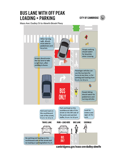
Graphic 1: How to Use the Dedicated Bus Lanes
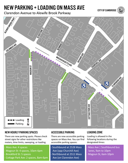
Graphic 2: Loading and Parking between Alewife Brook Pkwy and Edmunds St
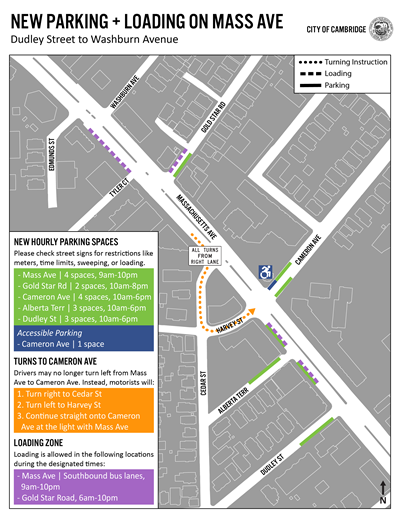
Graphic 3: Loading and Parking between Edmunds St and Dudley St
The Traffic, Parking and Transportation Department began installation of separated bike lanes between Dudley St and Alewife Brook Pkwy on Monday, November 8 at 8 p.m.
Remaining work will wrap up in early December. This includes:
- Installation of bus lanes
- Completion of signage, including side-street parking modifications and new accessible parking on Mass Ave
During the installation of bus lanes, crews will be painting the roadway surface red. This work will take place during daytime hours to take advantage of above freezing temperatures. During this time, additional traffic impacts are to be expected.
Recent updates to the plan include:
- Finalizing the layout for the corridor.
- Finalizing loading hours. Loading will be permitted in the inactive southbound bus lane from 9 a.m until 10 p.m. No loading and/or parking will be permitted overnight between 10:00 p.m. and 9:00 a.m.
- Installing a northbound bus lane. No loading and/or parking will be permitted northbound at any time.
- 2-hr Metered parking added on Magoun St, Gold Star Rd, Dudley St, Alberta Ter, Cottage Park Ave, and Cameron Ave.
- Additional safety features for bicyclists and pedestrians, including new signal phasing at Mass Ave and Cedar St to separate turning vehicles from pedestrians and bicyclists, a four-way stop at Harvey St and Cedar St, and two-stage turn boxes for cyclists.
- Addition of handicap parking in select locations.
For more information, visit the next window to view materials from our October 28 Community Meeting
We held a second community meeting to share updated plans for the Mass Ave corridor between Dudley St and Alewife Brook Pkwy on Thursday, October 28 from 6 p.m. to 8 p.m.
The Zoom webinar was posted here.
We have posted information from the meeting below:
In addition, we have posted background information that was use to create the slides above, including crash data and travel data from both 2016 and 2021.
There are already bike lanes on the corridor. Why is the City modifying the existing bike lanes? What are the benefits?
The existing bike lanes on this section of Mass Ave do not meet the standards set in the Cycling Safety Ordinance. These are too narrow and are placed between parked cars and the travel lane, which creates the hazard of someone riding to be “doored” and thrown into traffic. Numerous studies, along with federal and state guidance suggest that “separated” bike lanes are safer. Separated bike lanes are next to the curb and have a physical separator between the bike lane and traffic. Separated bike lanes are required under the Cycling Safety Ordinance.
What is the Cycling Safety Ordinance? Did the City hold a referendum or have hearings on the Ordinance?
The Cambridge City Council passed the Cycling Safety Ordinance in 2019 and further amended the Ordinance in 2020 to include additional streets and incorporate the timeline adopted for this project. An Ordinance does not require a referendum nor hearings but is voted on and becomes law if agreed upon by the majority of the council. Members of the City Council are voted on by Cambridge residents through the City’s unique Proportional Representation electoral process.
Can you remove the median?
The Cycling Safety Ordinance requires us to install separated bike lanes by April 2022. Removing the median or making any modifications to the existing curbs would not allow us to meet the April 2022 deadline for installation that is set in the ordinance.
Why do you have to implement in November, when the Ordinance requirement is in April 2022? (Couldn’t you implement this project in March or April 2022?)
The City cannot install markings during the winter and early spring due to cold weather. Five sections of Mass Ave are required before the April 2022 deadline. These are as follows: 1) Alewife Brook Pkwy to Dudley St, 2) Beech St to Roseland St, 3) Waterhouse St to Cambridge St, 4) Plympton St to Bow St and, 5) Small portions between Sidney St to Memorial Dr. This project must occur this Fall so that all sections are completed before the deadline.
When did outreach occur? Who did you talk to?
As of 10/19/2021, Cambridge community have sent approximately 300 emails to project staff with comments regarding this project. Traffic, Parking and Transportation staff engaged twice with business owners along the corridor. A first engagement informed business owners of the upcoming September 14 meeting and a second engagement during the week of October 11 to receive feedback on draft plans for the roadway and the proposed configuration of parking and loading.
During this time, draft plans were posted on the project webpage. We sent an e-mail asking for feedback to the project mailing list and attendees of the first community meeting. Additional flyers were also posted along the corridor to inform passersby of the recent updates.
What are the time savings for people riding transit?
The main benefit of a dedicated bus lane is that buses will be more reliable. This means people save time because buses arrive on schedule more often than without a dedicated bus lane. When buses are reliably on schedule, people do not need to add extra time to their trip to account for bus delays.
The project team also analyzed travel time impacts. We compared average bus travel time today with the average travel time with bus lanes. This analysis shows that buses may save a minute of travel time on average in each direction.
What are the expected impacts to people driving?
The project includes reconfigured turns at both Churchill Ave and Cameron Ave that will make it easier and safer to turn off Mass Ave. At Churchill Ave, this includes a dedicated left turn lane. At Cameron Ave, this includes a “jughandle” type turn that will route people driving onto Cedar St and Harvey St before continuing straight onto Cameron Ave. This will be accompanied with “All Turns from Right Lane” and “No Left Turn” signage.
General purpose traffic on Mass Ave will have one through lane in each direction rather than the existing two. This will increase travel times for people driving.
The City of Cambridge has a number of existing policies that are meant to encourage, walking, bicycling and riding transit over driving in a single-occupancy vehicle. These include: 1) The Vehicle Trip Reduction Ordinance, 2) The Parking and Transportation Demand Management Ordinance, and 3) Envision Cambridge, which is the Citywide Plan. This policy guidance forms the basis of our decision-making.
Can you make the loading on Mass Ave in the Southbound direction parking during certain hours?
In consultation with the Cambridge Fire Department, we determined that introducing parking on Mass Ave under the reconfigured layout would have a negative impact on emergency response vehicles. Specifically, having “floating” parking in the bus lane would narrow the width between the parked vehicle and the median to less than 18 feet, which is the needed width to deploy fire apparatus.
By limiting curb use to loading, it is likely that vehicle operators will be nearby and can move their vehicle in the case of an emergency. The Traffic, Parking and Transportation will study the loading configuration on a pilot basis and will consider modifications as needed.
Why is there no parking and/or loading in the Northbound direction?
The City determined that a bus lane would provide substantial reliability and travel time benefits all day in the northbound direction. We asked the MBTA to provide data on bus delay and reliability on Mass Ave. The City analyzed delay and unreliability throughout the day in both directions for the MBTA Route 77. The bus delay and unreliability is worse in the northbound direction. In addition, we found bus delay and unreliability at all hours of day.
The Traffic, Parking and Transportation Department will observe the operations of the bus lane northbound and make modifications as needed to address fire safety concerns and transit operations.
How did you decide which side-streets will have meters and/or loading?
Side-street meter and loading considerations were considered in direct consultation with abutting business owners and residents. In addition, the physical geometry of the street was considered, including the existence of features that would prohibit installing meters, such as hydrants, driveways, and insufficient sidewalk space. In addition, we considered the impact changes in side-street regulations would have on that street, including if a change would introduce vehicles on streets that do not have sufficient clearance to accommodate them.
Numerous private parking lots exist currently on this section of Mass Ave. Can residents and/or patrons of other businesses park there?
No publicly owned off-street parking lots exist in this section of Cambridge. Parking regulations on private lots are set by the property owner. To date, no private lot owners have expressed interest in sharing their lots with additional patrons and/or opening up their lots to other uses.
When will the project be installed?
Project implementation will take place in the weeks following the meeting, weather dependent. For the latest information on travel impacts, including the time and duration of work and its impacts, sign up for the project mailing list.
Starting the week of October 4, the Department of Public Works (DPW) began routine maintenance along the corridor.
This included repaving sections of the corridor on October 7 and 8. This was an already planned activity that was to take place regardless of the installation of separated bike lanes. Limits of the paving activity were done in consultation with the Traffic, Parking and Transportation Department to ensure that it was done in a manner that would facilitate the installation of the new roadway layout, including repaving the future location of the bike lane.
Starting the week of October 11, DPW also began repairs to address accessibility issues for people with disabilities. This ongoing sidewalk maintenance will not affect the location of the existing curb and does not allow us to consider further construction modifications to the corridor such as moving the location of the existing sidewalk or median.
For additional questions regarding paving and sidewalk maintenance, contact Kristen Kelleher at kkelleher@cambridgema.gov.
During the week of November 1, a contractor with the Traffic, Parking and Transportation Department may begin re-installing crosswalk markings on side streets that were removed during the recent repaving of the corridor. This does not mark the start of installation of the separated bike lane component of the project. That work will occur after the October 28 Community Meeting.
Tuesday October 12 and Wednesday October 13, we met with businesses to discuss the proposed plans for travel, loading and parking along the corridor. This included sharing an updated plan with proposed parking and loading regulations along with a cover letter with additional background on our decision-making process. You can view the materials that were shared with business owners here and here.
Additional outreach with the general public will follow.
On Tuesday, September 14 from 6:00 p.m. to 8:00 p.m., we held a virtual community meeting to discuss changes to Mass Ave from Dudley St to Alewife Brook Pkwy in relation to the Ordinance. During this meeting we:
- provided general information about the Ordinance,
- shared plans for Massachusetts Ave between Dudley St and Alewife Brook Pkwy, and
- gave an opportunity to ask questions about the plan.
View the slides here and recording.
Mt Auburn St at Holyoke St - Before and After
The images below show Mt Auburn St at Holyoke St before and after separated bike lanes were installed as a part of the Inner Mount Auburn Safety Improvement Project.
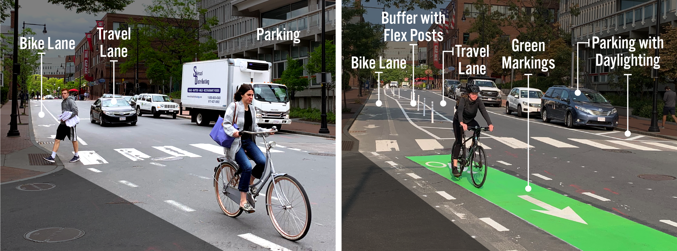
Key Components of Separated Bike Lanes
- Bike lanes create dedicated space for people who are biking.
- Buffers (painted lines on the street) create space between people biking and people driving. They help prevent unintentional collisions that could cause serious harm to the people involved. Depending on the location, there may be a parking lane next to the buffer area. In these instances, drivers can use the buffer area to safely get in and out of the car and to load and unload items.
- Flex posts are placed in the buffer area and serve as a vertical barrier in the buffer area.
- Travel lanes allow space for people to drive down the street, but can be used by anyone.
- Green markings help alert people turning from the travel lane that they should look out for people on bikes. These are generally installed at intersections and across driveways.
- Parking creates space for people to store their vehicles while they are in the area. This part of the street may also be designated as loading zones, which help make it easier for delivery people to do their jobs.
- Daylighting is when the parking lane is pulled back 20 feet to make it easier for people driving down the street and people waiting to cross the street to see each other. These areas are generally marked with lines on the ground. There may also be flex posts.
Why Install Separated Bike Lanes
Separated bike lanes provide more space and vertical separation between people on bikes and people in cars. More people are comfortable biking in separated bike lanes than in traditional bike lanes or in traffic with cars, buses, and trucks. Separated bike lanes also increase safety for people walking by reducing crossing distances. As we install separated bike lanes, we also look for opportunities to increase visibility at intersections, refresh crosswalk markings, and install appropriate pedestrian crossing signs.