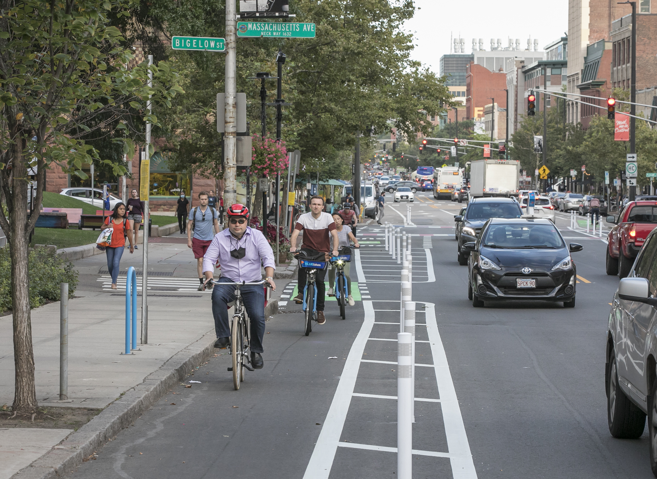
Cambridge ውስጥ ከፍተኛ ጥራት ባለው የብስክሌት መሠረተ ልማት ላይ የተደረገው ኢንቨስትመንት ሰዎች በከተማው ውስጥ የሚንቀሳቀሱበትን መንገድ ለውጦታል። ብስክሌት መንዳት ቀስ በቀስ ባለፉት ሁለት ዐሥርት ዓመታት እያደገ መጥቶ የከተማ አቀፍ ቆጠራዎች ከ2004 ዓ.ም ጀምሮ አራት እጥፍ መጨመሩን ያሳዩ ሲሆን፣ አሁን የብስክሌት ተጠቃሚዎች ቁጥር ከወረርሽኙ በፊት ከነበረው ደረጃ አልፏል። በጣም ጠንካራው እድገት የሚታየው የተለዩ የብስክሌት መስመሮች እና ለጋራ አገልግሎት የሚውሉ መንገዶች ባሉባቸው መተላለፊያ መንገዶች ላይ ሲሆን፣ አመቺ እና ደኅንነታቸው የተጠበቁ በመሆናቸውም ብስክሌት መንዳትን ለሁሉም ሰው የበለጠ ተደራሽ እንዲሆን አድርገውታል። ዛሬ 10% የሚሆኑት የCambridge ነዋሪዎች የሚንቀሳቀሱት በብስክሌት ነው። በከተማው ውስጥ ያሉት የBluebikes ጣቢያዎች በክልሉ ውስጥ በተከታታይ ከፍተኛ የተጠቃሚ እንቅስቃሴ ከሚታይባቸው መካከል ሲሆኑ፣ በ2024 ዓ.ም በሥርዓቱ ውስጥ ከነበሩት አጠቃላይ ጉዞዎች መካከል ግማሽ ያህሉ የተጀመሩት ወይም ያበቁት Cambridge ነው። መረጃው ግልጽ ነው፦ ከተሞች ደኅንነታቸው የተጠበቁ እና የተገናኙ ብስክሌት መንጃ ቦታዎችን ሲገነቡ፣ ሰዎች ለመንቀሳቀስ ብስክሌት መንዳትን ይመርጣሉ።
Cambridge ከ2020 ዓ.ም ጀምሮ እስከ 2026 ዓ.ም ድረስ በCycling Safety Ordinance (በብስክሌት ደኅንነት ድንጋጌ) ውስጥ የተቀመጠውን ወደ 25 miles (ማይሎች) የሚሆነውን የተለየ የብስክሌት መንገድ የመሥራት ከፍተኛ ራዕይ ለማሳካት እየሠራች ትገኛለች። እስከ ኦክቶበር ወር 2025 ዓ.ም ድረስ ወደ 17 miles (ማይሎች) የሚጠጋ መንገድ የተጠናቀቀ ወይም እየተሠራ የሚገኝ ሲሆን፣ ይህም ትልቅ ምዕራፍ የሚያመላክት እና ከተማዋ ግቡን ወደማሳካቱ እየተጠጋች መሆኑን የሚያመላክት ነው።
ከዚህ በታች የ2025 ዓ.ም ግምገማ ቅንጭብ እይታን ያገኛሉ፦
- በ2025 ዓ.ም Cambridge ከተማውን እና ክልሉን የሚያገናኘውን፣ ቁልፍ የመተላለፊያ መንገድ ግንባታ ፕሮጀክት የሆነውን Broadway Safety Improvement Projectን በማስጀመር፣ ደኅንነታቸው የተጠበቁ እና የተገናኙ ጎዳናዎችን ለመፍጠር የገባባውን ቃል ማሳካት ችሏል። ከColumbia Street እስከ Portland Street የሚዘልቀው የመጀመሪያው ክፍል አሁን ላይ የተለዩ የብስክሌት መንገዶች እና የተለያዩ የደኅንነት ማሻሻያዎች የተሠሩለት ሲሆን፣ ሌሎች መጓጓዣዎችን ለሚጠቀሙ ተጠቃሚዎች ቀላል እንዲሆን ታስቦ ቦታ የተቀየረላቸው የአውቶብስ ፌርማታዎችንም ይዟል። በሰፊ የማኅበረሰብ ተሳትፎ ድጋፍ የተደረገለት ፕሮጀክቱ በ2026 ዓ.ም የሚቀጥል ሲሆን፣ በዚህም ሥራ የCambridge Rindge and Latin School እና Main Library (ዋና ቤተ መጻሕፍት) አካባቢ ያሉትን ጨምሮ የቀሩት የፕሮጀክቱ ክፍሎች ይጠናቀቃሉ።
- የCycling Safety Ordinance አካል በመሆኑ፣ ጠባብ የመንገድ ስፋት ባላቸው እና አዲስ ከተገነቡት መስመሮች ጎን ለጎን የመኪና ማቆሚያን ማስተናገድ በማይችሉ መንገዶች ላይ የነበሩት መኪና ማቆሚያዎች ተነስተዋል። ለዚህ ምላሽ የከተማ አስተዳደሩ ዲሴምበር ወር 2024 ዓ.ም ላይ የParking and Transportation Demand Management (የመኪና ማቆሚያና የትራንስፖርት ፍላጎት አስተዳደርን)፣ የZoning Ordinance (የዞን ክፍፍል ድንጋጌን) እና የCommercial Parking Space Permits Ordinance (ለንግድ የመኪና ማቆሚያ ቦታ ፈቃዶች ድንጋጌን) አሻሽሎ ያቀረበ ሲሆን፣ ይህም «Flexible Parking Corridors (ተለዋዋጭ የመኪና ማቆሚያና መተላለፊያ መንገዶች)» በሚባሉት መተላለፊያ መንገዶች ላይ ለሚገኙ የንብረት ባለቤቶች ከመንገድ ውጭ ያለውን የመኪና ማቆሚያ በጋራ እንዲጠቀሙ ቀላል እንዲሆንላቸው አድርጓል። በ2020 ዓ.ም Bike Plan Network for Greater Separation እቅድ ውስጥ የተለዩት እነዚህ ኮሪደሮች፣ የመኪና ማቆሚያ ለውጦች የሚያስከትሉትን ተጽዕኖ በመቀነስ እና ለረጅም ጊዜ የፍላጎት ለውጦች በማዘጋጀት ረገድ የከተማዋን እያደገ የመጣውን የብስክሌት እና የአውቶብስ ትራንስፖርት መረቦችን ለመደገፍ የሚያስችሉ የተሻሉ የመኪና ማቆሚያ ደንቦች እንዲኖሩ ያስችላሉ። እነዚህ የድንጋጌ ለውጦች ያስገኙት ሌላኛው ውጤት ከ1990ዎቹ ጀምሮ ለረጅም ጊዜ ሥራ አቁሞ የነበረው Commercial Parking Control Committee (የንግድ መኪና ማቆሚያ ቁጥጥር ኮሚቴ) እንደገና ሥራ እንዲጀምር ማድረጋቸው ነው። ቃለ መሃላ የገቡት የኮሚቴው አዳዲሶቹ አባላት ሴፕቴምበር ወር 2025 ዓ.ም ላይ ስብሰባ ማካሄድ ጀምረዋል።
Separated Bike Lane Year Five Annual Report (የተለየ የብስክሌት መንገድ የአምስተኛ ዓመት ዓመታዊ ሪፖርት) የCycling Safety Ordinance ከጸደቀ በኋላ በመንገድ ግንባታ ርዝመት ረገድ የተመዘገበውን እድገት የሚያሳይ ሲሆን፣ ለመጨረሻው ዓመት የታቀደውን ቅድመ እይታም ይጠቅሳል።
- በ1ኛው ዓመት 4.19 miles (ማይሎች) የሚሆን የተለየ የብስክሌት መንገድ ሠርተን ማጠናቀቅ ወይም ግንባታ መጀመር ችለናል።
- በ2ኛው ዓመት 2.15 miles (ማይሎች) የሚሆን የተለየ የብስክሌት መንገድ ሠርተን ማጠናቀቅ ወይም ግንባታ መጀመር ችለናል።
- በ3ኛው ዓመት 3.67 miles (ማይሎች) የሚሆን የተለየ የብስክሌት መንገድ ሠርተን ማጠናቀቅ ወይም ግንባታ መጀመር ችለናል።
- በ4ኛው ዓመት 4.21 miles (ማይሎች) የሚሆን የተለየ የብስክሌት መንገድ ሠርተን ማጠናቀቅ ወይም ግንባታ መጀመር ችለናል።
- በ5ኛው ዓመት 1.90 miles (ማይሎች) የሚሆን የተለየ የብስክሌት መንገድ ሠርተን ማጠናቀቅ ወይም ግንባታ መጀመር ችለናል።
- በ6ኛው ዓመት 2.61 miles (ማይሎች) የሚሆን የተለየ የብስክሌት መንገድ ሠርተን ማጠናቀቅ ወይም ግንባታ መጀመር ችለናል።
- በ7ኛው ዓመት 4.86 miles (ማይሎች) የሚሆን የተለየ የብስክሌት መንገድ ሠርተን ለማጠናቀቅ ወይም ግንባታ ለመጀመር አቅደናል።**
*የማይሌጅ ድምሮች የተስተካከሉት በመደበኛ የGIS (ጂኣይኤስ) ልኬት ሂደት ላይ በመመሥረት ነው**ለዓመት 7 ከፊል ግምት
የCycling Safety Ordinance ፕሮጀክቶችን ለማግኘት፣ እባክዎ https://camb.ma/csomap ድረ-ገጽን ይጎብኙ።