May 24, 2024: Crosswalk Improvements at Hampshire St and Webster Ave
Crews will soon begin installation of crosswalk improvements at Hampshire St and Webster Ave.
Improvements will include:
- Installing a new crosswalk across Hampshire St
- Realigning Webster Ave
- Adding a crossing island on Webster Ave.
These improvements will slow turning traffic, shorten the crossing distance, and improve accessibility. This project is being delivered together with additional ramp and sidewalk improvements on Webster Ave.
See the design graphic below:
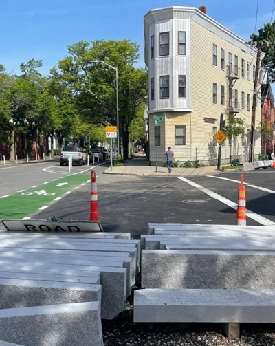
Photo of new curb ready for installation at Webster Ave.
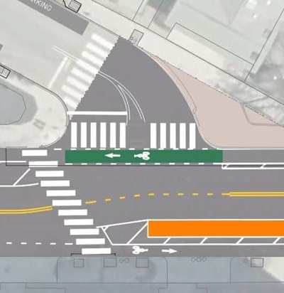
Design of new crosswalk across Hampshire St and realigned Wester Ave.
September 28, 2023: Separated Bike Lane Installation in front of One Kendall Beginning September 29
Starting Friday, September 29, we will begin work to install separated bike lanes on the block of Hampshire Street in front of One Kendall Square, between Broadway and Cardinal Medeiros Avenue. We have already made changes to the rest of the project area (between Inman Square and Cardinal Medeiros Avenue).
On Friday, September 29, we will modify signage and make changes to parking and loading in front of One Kendall Square. This includes relocating a loading zone, installing an accessible/disability space, and relocating the existing bus stop at Hampshire Street and Cardinal Medeiros Avenue to the other side of the intersection. Click here to view a map of the project's parking plans for specific information on what the new parking layout will look like.
Overnight Sunday, October 1, beginning at 8 p.m., we will install pavement markings on Hampshire Street between Broadway and Cardinal Medeiros Avenue. This includes installing separated bike lanes and green bicycle conflict markings.
Temporary Parking Restriction
There will be no overnight parking in front of One Kendall Square beginning Sunday, October 1, at 8 p.m. Work to install pavement markings will take one to two nights to complete, but is subject to change due to weather and crew availability.
Green Pavement Markings
Overnight on Sunday, October 1, we will install green bicycle conflict markings at intersections along Hampshire Street.
Installation of Flex-Posts Continues
Flex post installation on Hampshire Street and Broadway will continue on Friday, September 29. This will occur during the day. Work hours are between 7 a.m. and 3 p.m. No daytime parking restrictions are in place.
Additional days of work will be needed and we are working with the contractor to schedule additional installations in the coming weeks
September 13, 2023: Flex Post Installation Will Begin & One Kendall Update
Flex Posts
We will begin installing flex posts on Hampshire Street between Inman Square and Cardinal Medeiros Avenue on Thursday, September 14 and Friday, September 15. Hours of work are between 7 a.m. and 3 p.m.
Crews will be working in the street during these hours and intermittent partial closures of the travel lane and/or bike lane may be required. Please drive and bike carefully along the corridor while work is underway. We will begin by installing posts along bike lanes that are not next to parking spaces.
We will not install all flex posts this week. We anticipate that additional days of work will be needed to finish installing flex posts along remaining sections of the street, and will announce future installation dates on the project website and email list.
Installing Separated Bike Lanes and Relocating the Bus Stop at One Kendall Square
We anticipate that we will be able to relocate the bus stop at One Kendall Square the week of September 25. At that time, we will make changes to parking, including relocating a loading zone and installing an accessible/ disability parking space. These changes can be viewed in the project plans and parking plans linked at the top of this page.
We are targeting an early October installation for the separated bike lanes in this block (between Broadway and Cardinal Medeiros Avenue).
September 4, 2023: Pavement Marking Installation Continues
Project Implementation will continue the week of September 4, 2023
Pavement Marking Installation Continues
There will be no overnight parking on Hampshire Street between 8 p.m. and 4 a.m. the evening of Tuesday, September 5th, Wednesday, September 6th and Thursday, September 7th. This will allow us to finish the remaining project pavement markings. This work is weather-dependent and subject to change. We will send out an additional update with any changes to the work schedule. Should we finish earlier than expected, we will remove the No Parking signs, and parking will be allowed.
Next Steps
Curb and Sidewalk Improvements
Sidewalk improvements along the street are still underway. Crews are installing new ramps and sidewalk panels at Columbia St, Bristol St, and Cardinal Medeiros Ave, and repairing a sewer on Bristol St.
Installation of Separated Bike Lanes and Relocation of the Bus Stop at One Kendall Square
Once the sidewalk work is complete, we will relocate the bus stop at Cardinal Medeiros Ave and Hampshire St to its new location. Changes to signage and pavement markings on the block in front of One Kendall Square, including the bus stop relocation and installation of separated bike lanes, will take place after the sidewalk work is complete. We expect to complete work on this block by the end of September.
Installation of Flex-Posts
The installation of flex-posts will occur in mid-September after pavement markings are complete. This work will require daytime parking restrictions and will take approximately 2-3 days for each side of the street. We will restrict parking on one side of the street at a time. This work is not yet scheduled. We will provide additional information soon. All parking restrictions will be posted 48 hours in advance.
August 28th, 2023: Project Installation Continues
Project Implementation will continue the week of August, 28th.
New Pavement Markings
Last week crews installed layout markings. This refers to roadway paint that is put down ahead of permanent markings. Work will continue the week of August, 28th. We will prioritize the restriping of crosswalks, as weather permits. Striping of parking and bike lanes, including overnight parking restrictions, will resume the week of Tuesday, September 5th. We do not expect overnight parking restrictions during the week of August 28th. Inclement weather may prolong implementation.
Parking Regulation Changes Complete
Last week, we finished installing project signage. Parking is now only allowed on one side of the street. Signage and markings indicate the proper place to park. Vehicles parked in a No Stopping area may be ticketed or towed.
Questions about where to park? We've posted a map of the updated parking regulations. Signs on the street reflect what is shown on the map.
Curb and Sidewalk Improvements and Changes to the Bus Stop at One Kendall Square
Sidewalk improvements along the street are still underway. Crews are installing new ramps and sidewalk panels at Columbia St, Bristol St, and Cardinal Medeiros Ave. Once the sidewalk work is complete, we will finish relocating the one remaining bus stop at Cardinal Medeiros Ave and Hampshire St. Changes to signage and pavement markings on the block in front of One Kendall Square, including the bus stop relocation, will take place after the sidewalk work is complete.
Traffic Pattern Changes at Hampshire St and Broadway
Last Thursday, we implemented new signal timing and a change to traffic patterns at Hampshire St and Broadway. Leaving Hampshire Street, vehicles may only turn left onto Broadway. You may no longer continue straight or turn right.
To get to Technology Square from Hampshire Street, people driving must turn from Hampshire Street to Portland Street, to Broadway, to Tech Square. (Black dotted line on this map.)
August 24, 2023: Traffic Pattern Change
On August 24, 2023 the traffic pattern will change at the Hampshire Street/Broadway intersection.
As part of the street redesign, vehicles approaching the Hampshire Street/Broadway intersection on Hampshire Street will have to turn left onto Broadway, headed toward Kendall Square.
- People driving will no longer be able to go straight from Hampshire Street to Tech Square.
- People driving will no longer be able to turn right from Hampshire Street to Broadway.
To get to Technology Square from Hampshire Street, people driving will have to turn from Hampshire Street to Portland Street, to Broadway, to Tech Square. (Black dotted line on map below.)
People driving will still be able to travel in the other direction, from Tech Square to Hampshire Street.

View larger version of this image
August 16, 2023: Project Installation Starts Monday, August 21
The City of Cambridge plans to start installing the Hampshire Street Safety Improvement Project on Monday, August 21 (weather permitting).
New Pavement Markings
Crews will begin adding new pavement markings to the street overnight on Monday, August 21. Work will take approximately one to two weeks. Pavement markings will include crosswalks, lane lines, bus stops and separated bike lanes. Click here to view the final project plans.
Changes to Parking Regulations
Parking regulations on Hampshire Street will change the morning of August 21. City crews will replace metal signs that indicate parking regulations beginning at approximately 7 a.m. Questions about where to park? We've posted a map of the updated parking regulations. We'll update the signs on the street to reflect what is shown on the map.
Changes to Bus Stop Locations
Some bus stop locations will move on Monday, August 21. This will happen at the same time as changes to parking. The MBTA will post stop advisories at bus stop locations that are moving indicating where to wait for the bus. See "How will bus stops change?" in the drop-down menu above for more details.
Temporary No Overnight Parking
Beginning Monday, August 21 at approximately 8 p.m., there will be no overnight parking allowed on Hampshire Street. This is necessary to install new pavement markings on the street. Overnight parking restrictions will continue until pavement markings are complete, which will take approximately one to two weeks. This work is weather dependent, and work will not occur if the roads are wet.
Temporary paper "No Parking" signs will indicate the days and times that parking is not allowed.
Traffic Pattern Changes at Hampshire St and Broadway
Beginning later in the week of August 21, we'll implement the traffic pattern change at Hampshire Street and Broadway.
Leaving Hampshire Street, vehicles will only be able to turn left onto Broadway. They will no longer be able to go straight or turn right. Signage, pavement markings, and changes to signal timing will indicate the change.
To get to Technology Square from Hampshire Street, people driving will have to turn from Hampshire Street to Portland Street, to Broadway, to Tech Square. (Black dotted line on this map.)
July 31, 2023 Update: Milling and paving to begin
Milling and paving work will cause parking restrictions and detours between Tuesday, August 1, and Monday, August 7.
These dates are weather dependent, and the schedule could change. Work will occur between 7 a.m. and 6 p.m. At the end of each day, the roadway will return to the normal traffic pattern.
The City encourages people driving and biking to avoid the area if possible, especially during paving.
Where is this work taking place?
- Most of Hampshire Street (between Inman Square and Broadway)
- One block of Broadway (between Hampshire Street and Portland Street)
What is happening?
- Between Tuesday, August 1, and Friday, August 4, crews will remove the existing asphalt in the project area (this is referred to as “milling”). As the street is milled, the surface will be rough, with raised manhole covers. The roadway will be lower, making the curbs higher for parked cars. Please use caution when opening car doors, so they aren’t damaged on curbs.
- On Saturday, August 5, and Monday, August 7, crews will repave the roadway. Wet weather could delay this scheduled paving.
On-Street Parking Spaces
On street-parking spaces will be impacted during this work. Paper signs will indicate the hours and locations where parking is not allowed. These signs will be posted at least 24 hours before restrictions are in effect.
Detours
Detours will be in effect while work is underway (between 7 a.m. and 6 p.m.). At the end of each day, the roadway will return to the normal traffic pattern. Please pay careful attention to signs and directions from detail officers as you travel down Hampshire Street.
- There will be one lane open at all times for traffic headed eastbound (toward Kendall Square)
- Traffic headed westbound (away from Kendall Square) will be detoured away from Hampshire Street. Detour routes will change throughout the day and duration of this work: parts of Hampshire Street may be open to westbound traffic at different times during the project.
Side streets: At times, side streets will be closed at Hampshire Street, preventing access to Hampshire Street. Residents of these streets should plan vehicle trips accordingly and allow extra time for travel. At times, residents of one-way streets may have to travel the wrong way down the street to reach their homes. (Click here for the construction notice distributed to residents in the area.)
Abutters on Hampshire Street: As each section of the road is paved on Saturday, August 5, and Monday, August 7, it will be temporarily closed to all traffic except for emergency and City vehicles. Crews will reopen the roadway for abutters as soon as possible, but residents should allow extra time for travel.
Bus routes CT2 and 85
Two MTBA bus routes (CT2 and 85) travel through this area. The MBTA plans to detour buses headed westbound (away from Kendall Square) during this work. The MBTA will post flyers at bus stops with information on alternate routes and bus stops. You may also visit mbta.com/alerts/bus for more information.
Contact information
- If you have any questions about the paving operations or need assistance, including any special needs or disabilities that require an accommodation, please contact Dominic Almeida, Supervisor of Streets, at 617-349-6952 or dalmeida@cambridgema.gov.
- In case of an emergency after hours, please call the 24-Hour line at 617-349-4800.
Next Steps
We expect to begin installing separated bike lanes on Hampshire Street once paving is complete.
Beginning the week of August 7, you'll begin to notice changes to signage and meters. You should expect:
- Removal of meter heads. Parking at these spaces will still be allowed up to the posted time limit, if no temporary parking restrictions are in place.
- Changes to signs regulating parking on the street. Pay attention to the instructions on the posted signs when parking.
In mid- to late-August (roughly two weeks after paving is finished), we'll begin installing project markings, including changes to travel patterns and separated bike lanes.
Stay informed about future work related to the Hampshire Street Safety Improvement Project by signing up for the project email list.
July 17 Installation Update: Sidewalk Reconstruction, Parking Changes on Side Streets, Project Design Update
Sidewalk Reconstruction Work Underway
Last week, City crews started repairing sidewalks and curb ramps along Hampshire Street. This work will ensure that ramps and sidewalks comply with the Americans with Disabilities Act (ADA). No major detours are expected as part of this work. Intermittent sidewalk closures will be necessary. This will take approximately two more weeks.
Parking Changes Coming to Inman Street and Prospect Street
In the coming weeks, we will make changes to parking on Inman Street and Prospect Street, close to their intersections with Hampshire Street. These changes were shared as part of the June draft project plans. The changes include:
- Installing three metered spaces on Prospect Street
- Install two accessible/disability spaces, one on Inman Street and one on Prospect Street
We expect to have these changes made by the end of July, before implementation of the project.
Revisions to Project Design
Thank you to everyone who provided feedback on draft project plans. We expect to post the final design for the project at the end of July. We are looking into making changes based on recent feedback. Key changes to the design we are considering include:
Parking change between Inman St and Prospect St:
A different option for parking between Inman Street and Prospect Street. The new layout would place more parking on the south side of the street and add two new metered spaces.
Pilot to add more parking between Portsmouth St and Bristol St:
We are looking into testing out narrower bike lanes for one block between Portsmouth Street and Bristol Street. This would add about six to eight additional permit parking spaces to this section of the street. In the designs shared at the June meeting, this section of the street had no parking.
This change would remove the proposed 4-foot painted median and narrow the bike lane by approximately 2 feet in each direction for this block. These bike lanes would be about 6 inches narrower than the City's standard for snow clearance. This design would be a pilot only, and parking could be removed in the future if the narrower bike lanes makes snow removal too difficult.
Relocated accessible/disability parking space:
We'll relocate the current accessible/disability space at 111 Hampshire Street to the intersection of Windsor Street and Hampshire Street. This will improve the spacing of accessible parking along the street and provide accessible parking in an area with business activity. The space at 111 Hampshire St. was previously installed at that location for a resident who no longer lives at that address.
Final plans coming later this month:
We expect to share more information on these changes, including posting a final copy of the design, by the end of the month.
Next Steps
- Complete sidewalks repairs (~end of July)
- Finalize project designs (~end of July)
- Changes to parking on Inman Street and Prospect Street (~end of July)
- Mill and pave the roadway (after sidewalk repairs are complete)
- Install new pavement markings
- Install flex posts to separate bike lanes from parking and general travel lanes