U.S. flag

An official website of the United States government

Official websites use .gov
A .gov website belongs to an official government organization in the United States.

Secure .gov websites use HTTPS
A lock ( ) or https:// means you’ve safely connected to the .gov website. Share sensitive information only on official, secure websites.

A cyclist rides in a flex-post separated bike lane in Porter Square. He is headed toward a section of the bike lane that is painted green to indicate to cars that bikes have the right of way.

Mass Ave - Porter Square Safety Improvement Project

Project Complete: Installed Summer 2022 

This page is no longer regularly updated. 

Through the Porter Square Safety Improvement Project, we installed .41 miles of quick-build separated bike lanes on Massachusetts Ave between Roseland Street and Beech Street. Our toolbox included pavement markings, signs, and flex posts. This project:

  • Improves safety for people biking in the project area
  • Improves safety for people walking at existing crosswalks
  • Improves safety for transit riders with enhanced markings and signage at bus stops
  • Implements changes in line with the Cambridge Bicycle Plan and Vision Zero Action Plan
  • Meets the requirements of the Cambridge Cycling Safety Ordinance, which includes the requirement to add separated bike lanes

Project Plans

Click here to view a full resolution copy of the plans for the project.

Click here to view a copy of the final engineering plans for the project.


Project Updates

August 25, 2022 Project Update: Separated bike lanes installed

A cyclist uses a separated bike lane near Porter Square  Separated  bike lane near Porter Square   Separated bike lane near Porter Square.

On August 24, 2022, we installed white stanchions ("flex-posts") in Porter Square between Beech Street and Roseland Street, after painting new pavement markings earlier this summer. Other changes to the area include:

  • New bike signals at the intersection of Beech Street and Massachusetts Avenue
  • Modifications to signal timing
  • Changes to parking regulations
  • New and updated signage

We plan to make a few more small changes to signage and signals in the near future. Going forward, we may make slight changes to the project area as necessary. If you have any questions, reach out to Assistant Director for Street Management Brooke McKenna at bmckenna@cambridgema.gov.

July 26, 2022 Project Update: Installation to Begin Tonight

This evening, we plan to begin installing separated bike lanes in Porter Square between Beech Street and Roseland Street. 

This work includes:

  • Installing new pavement markings
  • Changes to parking regulations
  • Modifications to signal timing
  • Installation of white stanchions, or “flex-posts”, to separate people biking and people driving

This work is weather dependent. In order to lessen the impact on nearby residents and businesses, most work will take place during the overnight hours, starting at 8 p.m. Parking restriction information has been posted in the project area. 

Click here or browse the tabs below for project designs. 

July 15, 2022 Project Update: Installation to Begin Soon

Within the next two weeks, we will begin installing separated bike lanes in Porter Square between Beech Street and Roseland Street. This work is weather dependent.

This work includes:

  • Installing new pavement markings
  • Changes to parking regulations
  • Modifications to signal timing
  • Installation of white stanchions, or “flex-posts”, to separate people biking and people driving

In order to lessen the impact on nearby residents and businesses, most work will take place during the overnight hours, starting at 8 p.m. Parking restrictions will be posted in the area at least 48 hours prior to the work taking place.

Stay tuned for additional updates. 

Click here or browse the tabs below for project designs. 

June 2022 Project Update #2: Median and Overhead Wire Removal Complete

Median and overhead wire removal is complete. Stay tuned for more information on project installation. 

June 2022 Project Update #1: New Parking Meters, Median and Catenary Wire Removal, and Updated Timeline

New Side Street Parking Meters
We recently installed parking meters on side streets in the Porter Square area, including on Mt Vernon Street and Davenport Street. These locations are shown on the project plans.

Median Removal Beginning June 9
As shared during our April 26 community meeting, we will remove a section of median between Roseland Street and Upland Road to allow for additional parking and loading within the project area. The city's contractor for the project will begin work at the site on Thursday, June 9. Intermittent lane closures are expected as part of this work. Parking restrictions are expected to be limited and will be posted 48 hours in advance.

MBTA Overhead Catenary Wires Removal Beginning June 11
The MBTA submitted a formal letter to Mayor Siddiqui and City Manager DePasquale on May 9 detailing its plans to remove the overhead catenary wires in Porter Square. A copy of the letter can be found here. To minimize disruption to the neighborhood, the removal of the MBTA wires will occur one month earlier than originally planned to coincide with removal of the median.

Previously, we indicated that overhead wire removal would occur at night beginning on Thursday, June 9. Due to weather and crew/equipment availability, the MBTA has shifted its approach and plans to begin wire removal during the day on Saturday, June 11. Going forward, work may occur during either daytime and nighttime hours, several days per week. This schedule is dependent on weather and crew availability. For questions regarding removal of the overhead wires, contact the MBTA.

Additional Parking and Loading
The removal of the overhead wires allows us to provide metered parking on Mass Ave within the project area. The latest plans for metered parking can be seen here. This includes four metered parking spaces in front of University Hall (1815 Mass Ave).

Project Timeline
We expect to implement separated bike lanes along the corridor in July. Pavement marking work will occur at night. Parking and lane closures are expected during this time. Work is weather dependent, and we will provide additional details closer to implementation.

Meetings and Outreach

April Business Outreach

On April 13, we visited businesses in Porter Square area to discuss changes to parking and loading in the square.

Update: 4/28/22

We have updated the pamphlet to include the latest set of plans, which incorporates additional parking and loading throughout the project. Click here to view a copy of the pamphlet.

In addition, posters were placed on the street to let visitors to the square know of the upcoming changes. See below for an example.

We have opened a survey to provide people an opportunity to provide their feedback on these proposed changes and will make changes based on the feedback we receive. Click here to access the survey.

We welcome your continued feedback. If you have any questions or are a business owner or manager and would like to request a follow up meeting, please reach out.

Community Meeting #3 - April 26, 2022

On Tuesday, April 26 from 6:00 p.m. to 8:00 p.m., we held a third virtual community meeting to discuss updates to the plan for separated bike lanes on Mass Ave from Roseland St to Beech St in Porter Square in relation to the Cycling Safety Ordinance.

During the meeting, we:

  • provided general information about the Cycling Safety Ordinance,
  • discussed updates to the plan
  • shared details on project implementation
  • gave an opportunity to ask questions about the plan

Click here to view a copy of the presentation slides. 

Click here to view a copy of the plans for the project.

Pop Up Information Session - March 22, 2022

On Tuesday, March 22 from 3:00 p.m. to 7:00 p.m., we held an outdoor pop up information session to discuss changes to Mass Ave from Roseland St to Beech St in Porter Square in relation to the Cycling Safety Ordinance.

During the event, participants:

  • Engaged directly with members of our staff,
  • Reviewed updates to the plan since the first community meeting,
  • Asked questions and received information

Materials from the event regarding Porter Square are available below. If you are looking for materials regarding the Mass Ave 4 Projects, these can be found on the Dudley to Beech, Roseland to Waterhouse and Harvard Square Bus Stops project pages.

Click here to view Board 1

Click here to view Board 2

Click here to view Board 3

Click here to view Board 4

Click here to view Board 5

Community Meeting #2 - March 15, 2022

On Tuesday, March 15 from 6:00 p.m. to 8:00 p.m., we held a second virtual community meeting to discuss changes to Mass Ave from Roseland St to Beech St in Porter Square in relation to the Cycling Safety Ordinance.

During the meeting, we:

Materials from the community meeting can be viewed below.

Click here to view a recording of the meeting

Click here to view a copy of the slides

Click here to view a full transcript of the meeting

Feedback Survey

4/12/22: These surveys are now closed.

Please fill out a brief survey to provide your feedback on the ideas we shared at Tuesday's Community Meeting. If you own or operate a business in Porter Square, we suggest filling out our Business Feedback Survey. This includes additional questions that are specific to business needs.

General Feedback Survey - For anyone

Business Feedback Survey - For businesses and their employees, offices (i.e., medical, dental), houses of worship, and other institutions with curbside needs.

Community Meeting #1 - January 25, 2022

On Tuesday, January 25 from 6:00 p.m. to 8:00 p.m., we held a virtual community meeting to discuss changes to Mass Ave from Roseland St to Beech St in Porter Square in relation to the Cycling Safety Ordinance.

During the meeting, we:

  • provided general information about the Cycling Safety Ordinance,
  • discussed constraints and opportunities along the corridor,
  • shared various options,
  • gave an opportunity to ask questions about the plan

You may view the presentation below. A copy of the presentation slides is available as well, along with a video recording of the comment period and the full transcript.

Background

Project Area Map

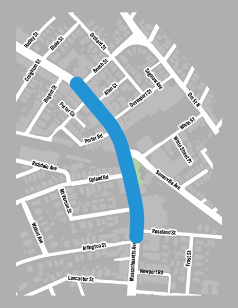
The project area includes the stretch of Massachusetts Avenue from Beech Street to Roseland Street. 

Frequently Asked Questions (FAQ)

Below is a list of frequently asked questions (FAQ) concerning the installation of Quick-Build separated bike lanes in Porter Square this Spring.

1. How much parking are you removing?
Below is the existing parking supply between Beech St and Roseland St.


2-Hour Metered Parking

35 spaces

Accessible (Disability) Parking

2 spaces

Loading Zone

2 spaces

Valet

2 spaces

Taxi Stand

2 spaces

At this relatively early stage of the project, we cannot say for sure what the final impacts will be. However, it is highly likely that all 2-hour parking spaces on Mass Ave will be removed. Some of these spaces could be relocated to side streets. We will know more regarding the impact to loading zones, the taxi-stand and impacts to the hotel valet as we get further along in the design and outreach process. Accessible/disability spaces will be maintained at or near their current locations wherever possible.


2. How does this project reduce injuries and increase safety? I would like to see more cyclists obey traffic laws.

Extensive research has shown that separated bike lanes improve user behavior and increase safety. For example, the current design incentivizes bicyclists to run red lights to avoid clusters of vehicles in traffic, or to ride on the sidewalk, further from vehicles. When safe, separated lanes are created, these negative behaviors are reduced. This is referred to as a Safe Systems Approach, which focuses on structural change, rather than the admonishment of individual behaviors. More information on the Safe Systems Approach, including sources, can be found here.


3. Can you provide more data on bus delay?

In 2018, the City studied bus delay and unreliability on most bus routes in Cambridge. We rated sections of streets on a scale from A to F based on how much delay, unreliability, and number of bus passengers. Any section rated as a D, E or F, was identified as a location of concern where bus delay and unreliability are high. In locations of concern, we may install dedicated bus lanes and priority at signals for buses. These locations of concern are mapped onto Cambridge streets. Click here to see a map of the locations of concern.

We identified all of Mass Ave north of Harvard Square as an area of concern. Within the section from Roseland St to Beech St, the worst delay and unreliability currently occurs in the Northbound direction. The 2018 study gave this section an F rating. There was significant delay, variability, and high ridership. The Southbound direction received a D rating.


4. Are you doing the same thing on other sections of Mass Ave?

Different sections of Mass Ave follow different timelines. Some, such as Porter Square from Beech Street to Roseland Street, are quick-build, while others may be done using a mix of construction and quick-build materials.


There are four segments of Mass Ave that have unique complicating factors including significant underground utility considerations, major bus stops and the MBTA’s electric catenary which presents significant overhead and subsurface utility considerations.  These four sections, collectively referred to as MassAve4, are on a longer timeframe. The City conducted an impact analysis on MassAve4 that was published in April 2021. 

Conceptual design and construction feasibility is underway for the sections of Mass Ave from Dudley Street to Beech Street and Roseland Street to Waterhouse Street. We began the community process in November 2021. Information about the ongoing work, including the November 2021 video presentation, can be found here.

5. Will there be a construction project after the quick-build project is complete? Can you remove the median or consider sidewalk-level bike lanes in the future?

While the quick-build design does not preclude a construction project in the future, no such project is currently programmed in the city’s 5-year capital plan. Through the MassAve4 process, the City is evaluating existing overhead and underground utilities, as well as other significant subsurface conditions such as the presence of cobblestones and/or abandoned trolley tracks. A thorough understanding of existing conditions is necessary to evaluate the constructability of surface infrastructure changes such as median removal and sidewalk-level bike lanes. For example, changes to a curb line to add a sidewalk-level bike lane would require movement of the catch basins to accommodate drainage.  Moving the curb could also trigger a significant amount of construction both above and below ground (e.g., relocation/upgrades to public and private utilities such as water or sewer pipes, gas mains, electrical and telecommunication duct banks, relocation of traffic signals and street lighting), and full depth roadway reconstruction.

Infrastructure projects of this scale usually take 2 to 3 years of careful planning and design, at least two years to construct, and are significantly more expensive than quick-build projects. The outcome is beneficial to the community, but the required construction activities are impactful and must be thoughtfully managed. An example of a major reconstruction project is Western Avenue. There were significant subsurface utility upgrades required to separate stormwater from the sewer system. Due to the extent of the subsurface construction, the city was able to implement major surface infrastructure changes, including a sidewalk-level bike lane. 


6. Are you incorporating the feedback from business owners and lessons from previous projects?

Our goal is to speak to every business owner along the corridor and learn how to best meet their needs. We are also considering changes in roadway markings and signage based on lessons learned from previous projects. More details regarding this information will be shared at the second community meeting. 
One of the major benefits of quick-build project is the ability to adapt quickly and make further changes. We will work with all stakeholders both before and after implementation and make adjustments if needed.


7. Is the City of Cambridge considering other types of bike lane separation than the white flex posts?

Flex posts are currently the City’s preferred separation type for Quick-Build Projects. Flex posts offer several benefits, such as: 

  • Relatively easy and inexpensive to procure
  • Allow for easy maintenance and street sweepers and plows can navigate in and around the posts 
  • Reflective elements enhance their visibility at night
  • Emergency vehicles such as fire trucks can drive over them if necessary

We are actively exploring additional types of separation, including concrete barriers, or other types of prefabricated materials. Any new separation type shall adhere to a variety of standards related to maintenance, crash tolerance, safety and aesthetics. However, at this moment we envision using flex posts for the foreseeable future, including for the Porter Square project.


Separated Bike Lane Example

Mt Auburn St at Holyoke St - Before and After

The images below show Mt Auburn St at Holyoke St before and after separated bike lanes were installed as a part of the Inner Mount Auburn Safety Improvement Project.

The left image shows Inner Mt Auburn St with a standard bike lane, travel lane, and a parking lane. The right image shows Inner Mt Auburn St with a bike lane, buffer area with flex posts, a travel lane, a parking lane, and daylighting.

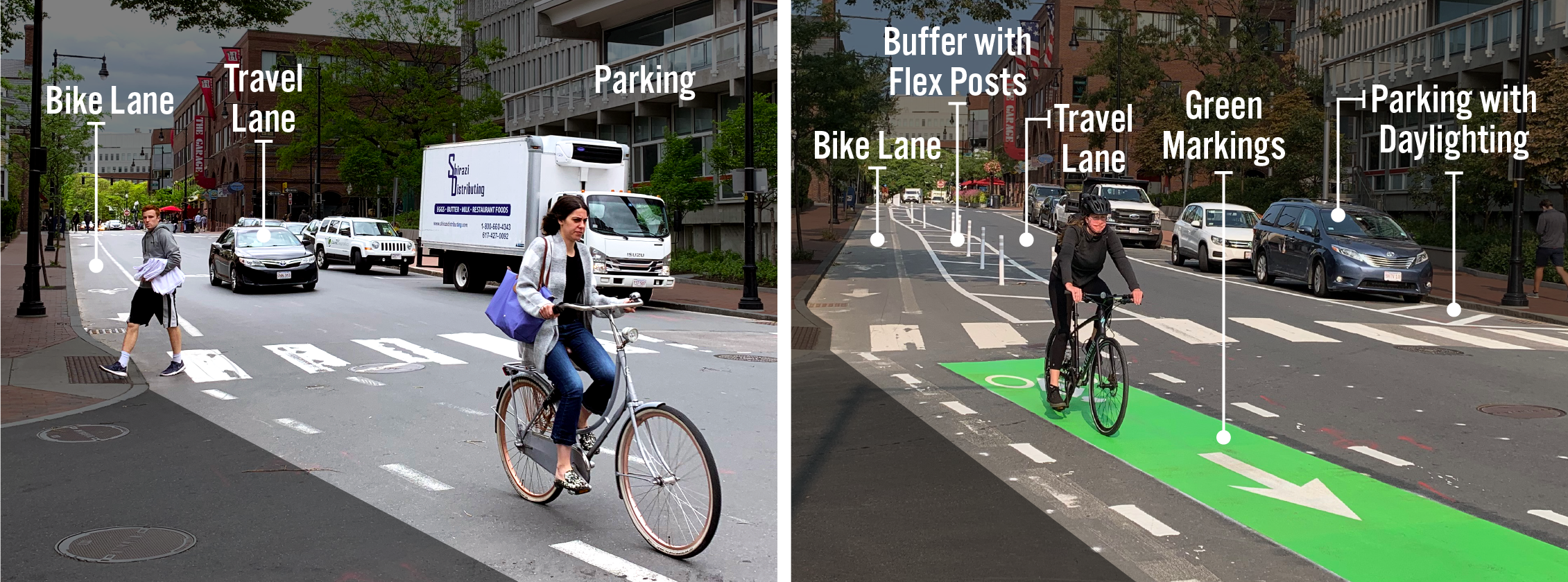
Key Components of Separated Bike Lanes

  • Bike lanes create dedicated space for people who are biking.
  • Buffers (painted lines on the street) create space between people biking and people driving. They help prevent unintentional collisions that could cause serious harm to the people involved. Depending on the location, there may be a parking lane next to the buffer area. In these instances, drivers can use the buffer area to safely get in and out of the car and to load and unload items.
  • Flex posts are placed in the buffer area and serve as a vertical barrier in the buffer area.
  • Travel lanes allow space for people to drive down the street, but can be used by anyone.
  • Green markings help alert people turning from the travel lane that they should look out for people on bikes. These are generally installed at intersections and across driveways.
  • Parking creates space for people to store their vehicles while they are in the area. This part of the street may also be designated as loading zones, which help make it easier for delivery people to do their jobs.
  • Daylighting is when the parking lane is pulled back 20 feet to make it easier for people driving down the street and people waiting to cross the street to see each other. These areas are generally marked with lines on the ground. There may also be flex posts.

Why Install Separated Bike Lanes

Separated bike lanes provide more space and vertical separation between people on bikes and people in cars. More people are comfortable biking in separated bike lanes than in traditional bike lanes or in traffic with cars, buses, and trucks. Separated bike lanes also increase safety for people walking by reducing crossing distances. As we install separated bike lanes, we also look for opportunities to increase visibility at intersections, refresh crosswalk markings, and install appropriate pedestrian crossing signs.

Page was posted on 8/24/2021 5:10 PM
Page was last modified on 7/24/2023 10:20 PM
Contact Us

How can we help?

Please provide as much detail below as possible so City staff can respond to your inquiry:

As a governmental entity, the Massachusetts Public Records Law applies to records made or received by the City. Any information received through use of this site is subject to the same provisions as information provided on paper.

Read our complete privacy statement


Service Requests

Enter a service request via SeeClickFix for things like missed trash pickups, potholes, etc.