Bicycle Wayfinding
Wayfinding Signs to Minuteman Bikeway and BU Bridge
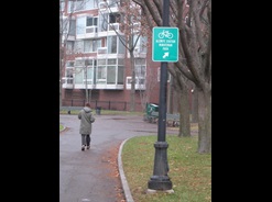
Signs have been installed to help people bike between the Minuteman Bikeway/Alewife and the Charles River Bike Paths/Harvard Square, as well as between Inman Square and the Boston University (BU) Bridge.
The goal of the signs is to show people a direct yet pleasant route between these popular bicycling destinations, using mostly bike lanes, local streets and off-street paths. Of course, people may choose any route they would like – the city encourages bicycling on all streets – but it is not always obvious what the easiest way to travel is for certain destinations. Wayfinding systems like this enable people to easily get around, providing a route that is simple to follow for a wide range of users.
Wayfinding Maps
Check out the maps and look for the green signs pointing in the direction you are heading, and you’ll be on your way!
Minuteman Bikeway Maps
Link to Inbound Map (Alewife T/Minuteman Path to Harvard Square/Charles River)
Link to Outbound Map (Harvard Square/Charles River to Alewife T/Minuteman Path)
Find out more about the Minuteman Bikeway.
Boston University (BU) Bridge from Inman Square Maps
Link to Southbound Map (Inman Square to BU Bridge)
Link to Northbound Map (BU Bridge to Inman Square)
For More Information
For more information about bicycling in Cambridge contact cddat344@cambridgema.gov.