Zoning Ordinance Maps

Zoning Overlay Map

As a public service, this page provides links to electronic versions of the Zoning Maps of the City of Cambridge, Massachusetts. Our goal is to make zoning more accessible by placing this information on the Web. The Ordinance is a complex legal document.

The maps available through this web page include all amendments approved by the City Council up to Ordinance #2022-21 ordained on April 3, 2023 unless otherwise stated.

PLEASE NOTE: The online versions of the City of Cambridge, Massachusetts Zoning Ordinance and Maps are provided for reference and the convenience of having the Ordinance in a computer-readable format. The print version of the Zoning Ordinance, together with any amendments adopted by the City Council subsequent to the most recent update to the print version, remains the official version of the Ordinance. If any discrepancies exist between the print and web versions of the Zoning Ordinance, the print version, together with any City Council amendments, shall be considered correct. There is an interim period between the date when the City Council adopts a text or map amendment to the Zoning Ordinance and the revision date of this web site. Zoning text and map amendments, as well as corrections, will be placed on-line as available. Recent amendments to the Zoning Ordinance may appear on the Web prior to being incorporated into the print version of the Ordinance.

Citywide Zoning Maps

Zoning Overlay Map
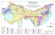
Base Zoning Districts Map
Base zoning regulations apply throughout the city. Every location in the city has a base zoning district with a Residence, Office, Business, Industry or other special designation.

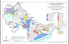
Overlay Zoning Districts Map
Overlay zoning districts modify the regulations of the base zoning district in different ways as set forth in the ordinance. Not every location is within an overlay district, but a location may be part of more than one overlay district.


Overlay District Zoning Maps

More detailed maps are available for some unique districts or categories of districts. However, individual maps are not available for every district. Please consult the citywide maps above for a comprehensive view of all zoning districts.

Planned Unit Development (PUD) Districts Map Planned Unit Development (PUD) Overlay Districts
PUD districts establish special regulations and review processes for mixed-use developments on large development sites. See Article 12.000 and Article 13.000.

Alewife Overlay Districts Map Alewife Overlay Districts (AOD)
Special regulations apply in the areas near Alewife Brook Parkway, north of Fresh Pond and south of the Alewife Reservation. See Section 20.90.

Mixed Use Residential Overlay Districts Map Mixed-Use Residential (MXR) Overlay Districts
There are MXR districts in different parts of the city, which allow limited non-residential use in otherwise residentially zoned districts. See Section 20.20.

Alewife Transfer of Development Rights MapCambridgeport Transfer of Development Rights Map
East Cambridge Transfer of Development Rights Map
Transfer of Development Rights (TDR) Areas
Some districts (base or overlay) contain provisions allowing for the transfer of buildable floor area from one lot to another. See Article 21.000.

Massachusetts Avenue Overlay District: Porter Square Massachusetts Avenue Overlay District: Porter Square Subdistrict
Special regulations apply to hotel/motel uses in the Porter Square area. See Subsection 20.104.3.

Map of Grand Junction Pathway Overlay District

Grand Junction Pathway Overlay District
Modifications to development standards to promote the development of a public pathway along the Grand Junction Railroad right-of-way. See Section 20.1000.

Pathway Overlay District Map Pathway Overlay District
Future open space uses are anticipated along the right-of-way of the inactive Watertown Branch rail line near Fresh Pond. See Section 20.400.

Lesley Porter Overlay Zoning District Lesley Porter Zoning Overlay District
Special provisions for educational use are allowed on land owned by Lesley University on its Porter Square campus. See Section 20.500.

 Basement Overlay Zoning District Map Basement Housing Overlay District
Special regulations in this district allow for the establishment of new housing units by special permit in the basements of existing buildings, with limitations. See Section 20.600.

Cambridge Highlands Overlay District Map Cambridge Highlands Overlay District
Modifications to the Residence B base zoning requirements. See Section 20.800.

 Map of Central Square zoning overlay districts Central Square Zoning Overlay District
Map of Central Square Zoning Overlay District.  See Section 20.300.

 Map of Harvard Square zoning overlay districts Harvard Square Area Zoning Overlay Districts
Map of Harvard Square Overlay District and Institutional Overlay District in the Harvard Square area.
Mass and Main Subdistrict  Mass and Main Residential Mixed Income Subdistrict


View or Purchase Print Copies of the Zoning Ordinance and Maps

  • To purchase a paper copy of the Zoning Ordinance, visit the Office of the City Clerk at City Hall, 795 Massachusetts Avenue in Central Square. The Clerk's office also has copies of the Zoning Map for sale. Call 617/349-4260 for more information.
  • Zoning Maps may also be purchased at the Community Development Department offices, 344 Broadway. Call 617/349-4600 for more information.

For More Information

Visit the Contact Us page.